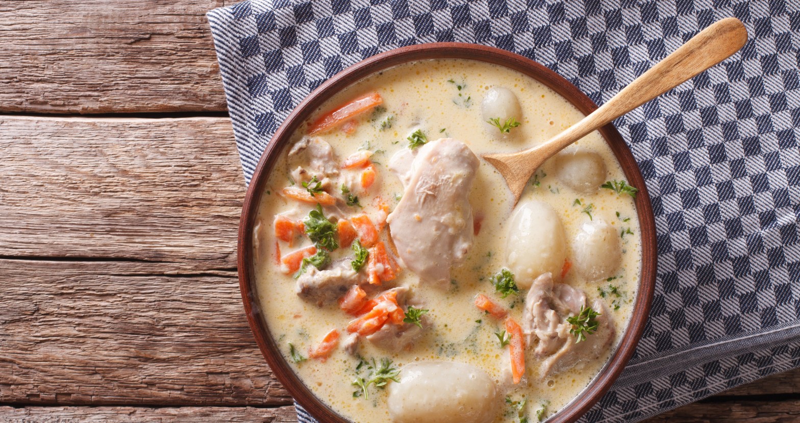
At the end of the eighth century, by decree of Charlemagne and under the supervision of the wise men Wlemar and Saxmund, the customary law of the Frisians was codified. It is called the Lex Frisionum. Its jurisdiction included the land between Flehum and Sincfalam, between the rivers Vlie and Sincfalam river. The River Flehum flowed into the North Sea, where the sea strait Vlie is located today, between the Wadden Sea islands of Terschelling and Vlieland. Sincfalam, also written as Sincfalem, refers to the inlet of the Zwin in the region of Flanders. It still marks a border, currently between Belgium and the Netherlands. Sincfalam can be translated as ‘plain of wet lowlands’. In other words, a watery mess. Waterzooi, meaning ‘watery mess’ in the Flemish speech, happens to be a traditional dish of Flanders. We noticed that not much has been written about this southern frontier of early-medieval Frisia. This blog post is an attempt to fill in the gap.
If you think Waterzooi is a straightforward dish, think again. Actually, it is quite a lot of work to prepare it. A lot of cutting and vigorous chop-chopping before you start boiling it into a mess. Voilà, your ultra-short version of the history of Flanders! So, the reader has been warned before starting this long-read about the March of Flanders.
1. Sincfal or Sincfala?
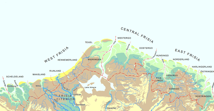
The overall jurisdiction of the Lex Frisionum, a codex written in the Latin language, was the lands between Sincfalam fluvium ‘Zwin river’ and Wisaram fluvium ‘Weser river.’ The Lex Frisionum was written at the end of the eighth century, between 785 and 794, but its clauses possibly date back to the end of the sixth century (Henstra 2010). However, the laws of Frisia differed slightly between the three civitates ‘subregions’ of Frisia. These were: (1) civitas West Frisia, as mentioned, between the River Zwin and the River Vlie, (2) civitas Mid Frisia — also named Central Frisia, a label we find a little too presumptuous for our taste — between the River Vlie and the River Lauwers, and (3) civitas East Frisia between the River Lauwers and the River Weser.
Tusscen der Wesere enten Zwene,
Dat tien tiden hiet Sincval,
Wart ane Gode bekeert al,
Bi Willebrorde, bi Willade,
Ende bi Bonefacis predicade.
Spiegel Historiael (Jacob van Maerlant, ca. 1330)
Between the River Weser and the Zwin, | Back then called Sincfala, | Converted to God before, | By Willibrord’s, by Willehad’s, | And by Boniface’s sermons.
There are different theories about the linguistic origin of the name sincfalam. One is that sincfalam refers to land or dike subsidence, or to the sinking of riverbanks (Coen 2008). Val, meaning to fall/to drop, is a toponym found also in the province of Zeeland. Sincfal as in ‘sink-fall’ would then, however, be a pleonasm (Van Renswoude 2021). Another explanation is that sincfal derives from the word swytfal. This developed from the Old Germanic word swinþa meaning powerful. The word fal meaning waterway, which might have derived from the River Waal called Vacalus in the Latin language (Kuiper 2013). Swinþa later developed into swīth and into swyt. Swytfal then would have been written as suitfal, and through a clerical error written as sincfal, because of the c and t being mixed up. The latter was not uncommon. However, if you follow this theory, equally well swytfal might have been a clerical error, and it just was sincfalam from the start (Van Renswoude 2021).
We stick with what we started with this blog post, a waterzooi. Sinc is an older variant of sink or zink, meaning (wet) lowland, a basin, and fala might very well be related to the Swedish word fala, meaning plain (Van Renswoude 2021). Hence, plain of wet lowlands — or in more fashionable language: The Big Sink. The explanation of wet lowlands fits smoothly with how the landscape of West Flanders must have looked at the closing of the eighth century. A seashore with flat, barren tidal marshlands, intersected by many creeks and inlets, with rivers and streams flowing from the interior. An area regularly flooded by the sea and bordered by wet peatlands and swamps. For this reason, a true sincfala, a true waterzooi. Albeit with loads of added salt. Contrary to most academic studies, we humble hikers, therefore, use Sincfala instead of Sincfal. We used to be pleased that the museum for local history of the Zwin Region in the seaside resort of Heist-aan-Zee, next to the town of Knokke, was correctly named Sincfala, until in 2022 they somehow felt the need to rename the museum HEY.
For much of its history, Flanders remained a watery mess. After the Flemings had succeeded in embanking most of their coastal lands with dikes during the High Middle Ages, the Eighty Years’ War in the second half of the sixteenth century and the War of the Spanish Succession at the start of the eighteenth century turned the wider Zwin region into a continuous battleground. For years on end, both sides held their frontlines by inundating the Zwin region, allowing tidal movements to carve new gullies into the landscape (Winstein 2003). This came on top of fortresses being built, dikes demolished, and towns and villages ruined — all thoroughly ravaging the historic landscape of Flanders. And that is without even mentioning the Great War and the Second World War. The reader can imagine the rest — “In Flanders fields the poppies blow” (McCrae 1915).
The watery-mess explanation of the word sincfala pairs well with one of the explanations concerning the names Flanders and Fleming. These names, first recorded on a golden coin from the seventh century (Universiteit Gent 2025), might be related to the Germanic flauma meaning ‘flood’, or the Old High German verbs flewen and flouwen, the Old Norwegian verb flaumr, the Mid Frisian verb floeie, or the Dutch verb vlieten. And, obviously, also the River Fleet, a tributary of the River Thames in Londen. All meaning ‘to flow.’
It was the Roman geographer Pomponius Mela described lacus Flevo (‘lake Flevo’ modern IJsselmeer) in the Netherlands and gave it its name. That was in the first half of the first century AD. Also the waterbody Flevo, later named Flie or Vlie, is related to ‘to flow’ as well. These words would also be related to the word flâm in Ingvaeonic, also called North Sea Germanic. Therefore, the names Flanders and Fleming would point to a flooded landscape (Verhulst 1995, De Maesschalck 2019, Toorians 2021).
As so often with etymology, another — completely different — explanation of the name of Flanders is that the word stems from the proto-Celtic word wlana meaning ‘wool’. Under Roman influence the word was extended into wlanaria (Clerinx 2023). Lastly, according to Chronique de Flandre written in the fourteenth century, the word vlaanderen has its origins in the name of the wife of (the fictional figure) Count Liederik, namely Flandrine (De Maesschalck 2019). Anyway, the iron-armed Flemings are quite capable to restart another war on this etymological issue, so we let it rest before making a rude mistake.
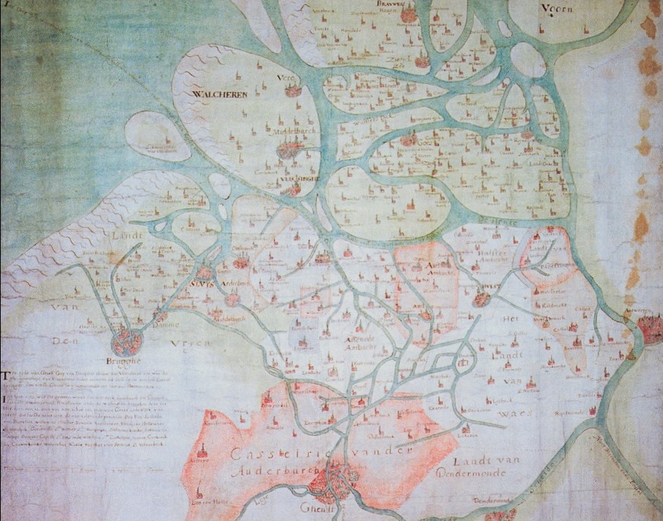
Most literature and studies equate Sincfala with the Zwin, referring to the current inlet in West Flanders, just south of the border with the Netherlands (Claerhout 1886, Knol 2021). By the way: it must be the Zwin in the wider region of Flanders, not the Swin located between the lakes Fluessen and Slotermeer in the province of Friesland, nor the Suyder Swin, a sixteenth-century sea gully north of the former Wadden Sea island of Wieringen in the province of Noord Holland. Even more misleading is the association with the River Świna in Poland, whose estuary does show some similarities with that of the Zwin in Flanders.
But is it, really? Is Sincfala truly identical to the inlet Zwin as we know it today? Several scholars argue otherwise. They suggest that Sincfala refers instead to the coastal zone around the mouth of the stream Honte or Hont (Henstra 2012, Van der Berg 2016). This stream initially formed a secondary branch of the River Scheldt before gradually evolving into what we now call the West Scheldt. Its river mouth was known as Zwake.
Other historians place Sincfala near the West Scheldt (De Langen & Mol 2021). But what does ‘near’ mean, exactly? Still others view Sincfala as part of the mouth of the Zwake, with the Zwin being merely a smaller offshoot of the Honte (Coen 2008). One interpretation even describes the Zwin as being connected via multiple channels to the Honte’s mouth, within a dynamic coastal landscape of islands such as Cadzand, Koezand, Schoneveld, Waterdunen, Wulpen, and Zuidzande (Zijlmans 2016). The simplest geographic definition we encountered? “Sincfala is the [huge] estuary of the River Scheldt” (Bremmer 2020).
And finally, the most recent interpretation — relating to the southern frontier of early-medieval Frisia — offers a more general take: “Arguably, parts of Flanders and North Frisia [Nordfriesland] also formed part of the Frisian area at certain points in time” (IJssennagger-van der Pluijm 2021).
It all begins to feel a bit like the Infinite Improbability Drive of the Starship Heart of Gold (Adams 1979).
Indeed, it becomes a bit of a watery mess when you zoom in. Confusion generated by science because the pixels of the historic image they present to us are still too few. Yet this confusion is not purely academic. Its roots lie in politics and war — or better yet, in war and politics.
In the early seventeenth century, during the Eighty Years’ War between the Dutch Republic and the Spanish Crown, Flemish interests manipulated geography to their advantage. To bolster the claim that the Dutch–Flemish border lay further north — specifically at the River West Scheldt — a map was deliberately falsified. Surveyor Lieven van Thuyne conveniently erased the inlet Zwin, historically the Sincfala border of Frisia, entirely from the map. The aim was to argue that the Generality Lands of Zeelandic Flanders did not belong to the Dutch Republic.
In the nineteenth century, the same debate resurfaced. Once again, it was claimed that Zeelandic Flanders had never been part of Frisia. This position, not coincidentally, aligned with Belgium’s interest in redrawing the national boundary at the River West Scheldt rather than the Zwin (Zijlmans 2016). We would not be surprised if some Flemings still cling to that line of argument today.
Aside from the confusion some academics have created with pixel-poor definitions of Sincfala, the variation in interpretations could suggest that the jurisdiction of the Lex Frisionum did not necessarily extend that far south in the Early Middle Ages, as is often assumed. This opens the door to the possibility that the southern border of Frisia might just as well have been the island of Walcheren (pagus Walacria) — and no further.
Do we hear distant cheers from West Flemings? Shouting hurray? At last, free from die Vriesen fel ende quaet — ‘the Frisians, fierce and wicked’ — as the thirteenth-century West Flemish poet Jacob van Maerlant described them. But hold your horses. And your boats. Not so fast. The Frisians still might be your daddy.
Let’s continue.
2. Romans moving in — first century BC
Although the etymological explanation of Sincfala matches the water-messy area of the delta of the stream Honte and inlet the Zwin, it is not specific enough to tell up to where the Frisians had sway over the area. Neither does the Lex Frisionum give more details as to where exactly its jurisdiction stretched. But, no worries. The area has been a frontier much older than the Early Middle Ages. Already in the first century BC the fighting had started. They were Romans pushing north and arrived at the maritimi loca ‘coastal districts’. Indeed, the region is a border area for almost 2,200 years. At least 2,200 years.
At the dawn of the Common Era, the landscape of what is now the region of West Flanders and the province of Zeeland looked markedly different from today. The coastline was still more or less intact — a continuous row of low dunes forming a natural barrier against the North Sea. Behind this protective dune wall lay vast wooded peatlands and swamps. The coastline itself likely stretched several kilometres further west than it does now.
These so-called old dunes formed a broad semi-circle, running from what is today the town of Nieuwpoort in Belgium to the village of Westkapelle on the island of Walcheren in the Netherlands (Bracke 2015). Nearly all of this ancient old dune habitat along the southern North Sea coast has vanished — except in the area south of The Hague, where remnants can still be seen. See also our blog post Rowing Souls of the Dead to Britain — The Ferryman of Solleveld about a unique ship burial in the old dunes in the province of Zuid Holland.
Between ten and fifteen kilometres inland in Flanders, running roughly parallel to the coast, lay — and still lies — the drier, elevated sandy ground. Along this sandy ridge ran the old Roman road, now known as Zandstraat or ‘sand street’ (Deckers 2017). It was along this cover sand edge, bordering the wetlands to the west — especially at points where waterways offered access to the sea — that the first larger settlements began to emerge.
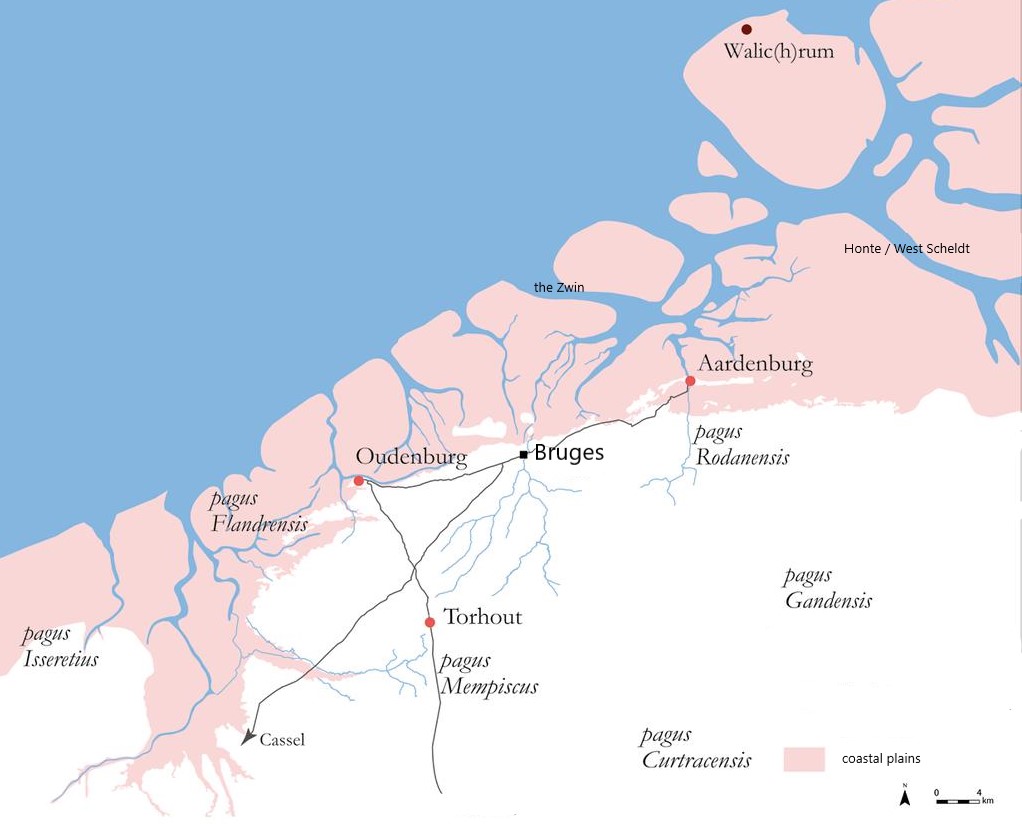
Classic examples in Flanders include Bruges, Oudenburg, and Veurne. Further afield, Bergues and Bourbourg in present-day France, as well as Aardenburg and Oostburg in the Zeelandic Flanders region of the Netherlands, also fit this pattern (Tys 2018, Lichtenberg 2011). Indeed, a lot of burghs. We will come back to that story later in this blog post.
At the time the armies of Julius Caesar arrived in what is now Belgium, the mouth of the River Scheldt was located more to the north than it does today. Originally, the River Scheldt joined the River Meuse via the stream called Striene. “Ad fluminem Scaldem quod influit in Mosam” (‘where the River Scheldt flows into the Meuse’), quoted from the Commentarri de Bello Gallico ‘Commentaires on the Gallic War’ written between 58-49 BC by Julius Caesar himself. In fact, the confluence of the rivers Scheldt, Meuse, and the River Waal was a sea bay. It is where nature reserve Dintelse Gorzen is located today. You will pass it when hiking the Frisia Coast Trail. The Romans called this confluence of rivers Helinium, Helius or Helinius, what is today more or less the River Haringvliet. It explains the toponym of the modern town Hellevoetsluis, namely ‘foot of Helinius‘ or ‘lowest land of Helenius‘.
The mouths of the River East Scheldt and the stream Honte — the latter of which would eventually become the River West Scheldt — began to form shortly after the start of the common era (Coen 2008). At the mouth of the River East Scheldt, near the modern-day town of Colijnsplaat, stood the Roman port of Ganuenta. The name Honte (also known as Ont or Hont) is likely of Celtic origin, derived from the word onno, meaning swamp or pond. Due to increasing sea activity, the stream Honte gradually expanded eastward into the peatlands, eventually forging a connection with the River Scheldt. From that point onward, the River Scheldt had three separate routes to reach the sea: through the River Meuse, the River East Scheldt, or the stream Honte. What more could a river wish for? Apparently, much more — as we will see.
Many who are first will be last, and many who are last will be first. So it was with the modest stream Honte, which ultimately came out on top — transforming into the mighty River West Scheldt we know today, the sole surviving mouth of the River Scheldt. Between the years 1000 and 1200, the Honte steadily widened, consuming the peatlands along its course. By 1202, its mouth was referred to for the first time as mere — ‘sea.’ Around 1300, only remnants of the islands Koezand, Wulpen, and Schorrevelde remained at its estuary. From that moment on, nothing stood in the way of the North Sea pushing deep into the Scheldt valley.
The lands of Saeftinge and Stuyvesande had not yet drowned, but they could barely keep their heads above water. The great flood of 1377 fundamentally altered the situation at the mouth of the Honte: much of the island of Wulpen vanished beneath the waves. The flood of 1513 washed away its last remaining parts. Koezand was entirely submerged by 1570. The island of Cadzand, however, was narrowly saved — and was firmly fused to the rest of Zeelandic Flanders.
Check our blog post Atlantis Found! Wait, There Is Another One, or 7, Wait 12 in Total… No, 19! to have a more complete, if ever shifting, picture of the Frisian islands washed away.
INTERMEZZO
Name Scheldt — The oldest preserved name of the River Scheldt is Scaldis. Mentioned by the Roman historians Plinius (ca. AD 23-79) and Tacitus (ca. AD 56-120). Possibly the name is of Cetlic origin, namely scald, which means ‘shallow water’. Later, other forms developed like scalda, escalda, scaldi, scelde, and scelt. The latter still exists in a Flemish dialect as ‘t Scelt. In the course of the sixteenth century, the name Schelde sees the light of day (De Graeve 2010).
A famous Viking chapter was called the Scaldingi. It had its stronghold on the island of Walcheren in the province of Zeeland. The Scaldingi were pivotal in the successful conquest of the medieval Anglo-Saxon world. Under the command of Ubba the Frisian, also known as Ubba dux Fresciorum and Ubbi fríski, these Vikings were significant players in the Great Heathen Army. Amai, terrorizing England between 865 and 878. If you want to know more about the island of Walcheren and Ubba the Frisian, see our blog post Foreign Fighters Returning From Viking Warbands on also Ubba, and our blog post Walcheren Island. Once the Sodom and Gomorrah of the North Sea.
Ecologically, the first five centuries marked a period of a highly energetic North Sea. The previously closed coastline — an almost unbroken wall of dunes shielding the interior from the sea — began to give way. This was the result of shifting dune formation, sedimentation, and the silting up of tidal gullies across the broader North Sea basin (Dumolyn & Leloup 2016). These changes gradually depleted sediment sources within the basin, triggering a process of erosion along the southern North Sea coast. Deep inlets were carved into the interior, and vast amounts of peat were swept away to sea (Tys 2002).
Inlets such as the Yser and the Zwin also drained water from the spongy peatlands behind the dunes, causing the land to compact and shrink, making it even more vulnerable to the encroaching sea (Wintein 2003). In other words, sea-level rise in itself was not the primary issue. Most scholars have now moved away from the general theory of transgressions and regressions of the North Sea. Instead, they emphasize regional ecological and climatic conditions, including human impact on the landscape, as far more relevant factors (Van Steensel & Chamuleau 2021).
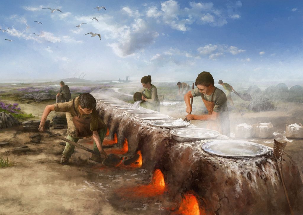
Main economic activity at the coastal plain of Flanders during the first centuries of the common era, was the production of salt. The Romans constructed big salt pans on the coast to extract salt from the sea. Salt was not only a very precious and thus an expensive trade commodity those days, but also essential for a big army that relied on food preservation. The fourth-century military forces in Britannia already needed about 110 tons of salt for the preservation of mutton. Possibly, the fortresses at Oudenburg and Aardenburg, and possibly Watten, were built to supervise the salt production (Dhaeze 2019). Toponyms like De Panne and Zeepanne remind of this economic activity.
Before the Romans arrived, people cut peat on a small-scale basis. The Romans started to cut peat, too, but still not massively (Wintein 2003). Maybe they did this to extract salt out of peat, or maybe as fuel for heating sea water to accelerate the extraction of salt. More to the north, at Polder Westmade between the cities of Rotterdam and The Hague, Romans did cut peat on a larger scale. Check our blog post The United Frisian Emirates and Black Peat. How Holland Became Dutch.
In the Late Iron Age, the River Scheldt already served as a border — specifically between the Menapii and Nervii tribes (De Graeve 2010). When the Romans arrived in the region in the first century BC, they waged numerous wars against the local tribes. These included the Morini (‘sea people’), the Menapii (‘hill people’), and the Eburones (‘yew people’). Julius Caesar defeated, slaughtered, and deported them all. Veni, vidi, vici was an understatement.
The tribes allied with Rome — the Cananefates and the Batavi — were permitted to settle in the former territories of the displaced Eburones and Menapii (Zijlmans 2016). The Romans, ever organized, established the province of Gallia Belgica. In the late third century, this province was restructured into three: Belgica Prima (eastern Belgium), Belgica Secunda (western Belgium), and Germania Secunda. The latter was formerly known as Germania Inferior, situated south of the Lower River Rhine.
In what is now roughly the province of Zeeland — then part of Germania Inferior — lived the Frisiavones, whose capital may have been Goedereede-Oude Wereld on the island of Goeree-Overflakkee (Dhaeze 2019). The Frisiavones are thought to have been Romanized Frisians (IJssennagger 2017). The Frisians proper — referred to as Frisii or Fresones in Latin — resided in Germania Superior, north of the Lower River Rhine along the coast and inland. Too superior, perhaps, to be conquered.
Once the sea became ‘high-energetic’ and began eroding and devouring the southern coastal zone of the North Sea, the people living along this strip followed suit — in a manner of speaking. They too became highly energetic. From the second century onward into the Early Middle Ages, piracy emerged as a widespread plague. The southern coast of the North Sea became the home base for these pirates, among them the Frisians, who at the time lived in what is now the north-western part of the Netherlands.
In his book Germania, written at the end of the first century, Tacitus speaks of the Ingaevones, denoting the peoples nearest to the sea. These peoples were, among other, the Chauci and the Frisians who were each other’s neighbours and shared the same salt-marsh culture living on terps (artificial dwelling mounds). With full dedication, both tribes would engage in the raiding business for centuries. Especially, the Chauci were feared pirates. Pillaging became so fierce, it made the Romans calling out to their deities with desperation how to defend their endless shores on both sides of the English Channel, and up to the mouth of the River Old Rhine. See our blog post Our Civilization — It All Began With Piracy for more background on the platinum age of piracy.
In the third and fourth centuries, Frisians and other Germanic tribes began migrating southward into the delta regions of the rivers Meuse, Waal, and Scheldt. They even moved upstream along the River Scheldt into the province of Belgica Secunda, an area known from the Carolingian era onward as pagus Wasia, or Land van Waas. Frisians also settled in the pagus Ghent, or Gentgouw, in East Flanders (Zijlmans 2016). At Zele, about twenty-five kilometers east of Ghent, archaeologists have uncovered typical hand-shaped Frisian ware vessels. Moreover, it was Frisians who revolted against Emperor Constantius I in the River Scheldt region in 293, although the Panegyrici Latini ‘praise speeches’ refer to them as Franci (Dhaeze 2019). The Romans crushed this rebellion and deported both the Frisians — labelled praedatores (‘looters’) — and the Chamavi to the interior of Gaul.
Piracy was so lucrative that the Roman admiral Carausius, tasked with securing the English Channel from pirates, actually allied himself with these same pirates and declared himself emperor of Britannia. The horror. That same year, 293, Constantius defeated this corrupted “Walter Kurz of the wilderness” in Britannia. The horror, indeed.
An intriguing find we would like to highlight is the ship’s figurehead discovered upstream on the River Scheldt, near the town of Appels in East Flanders. The so-called ‘dragonhead’ is carved from oak and dates from between 250 and 550 AD. Curiously, it is housed far from its origins, on the wrong side of the Southern Bight — in the British Museum. The ship it once adorned is estimated to have been about eighteen meters long.
Just imagine: raiders rowing up the river, armed to the teeth and searching for loot. Were they Frisians? Vikings, this one’s for you — with your famous dragon figureheads many centuries later, now you know where it all began. See our blog post A Raider’s Portrait From Appels. The Water World of the Migration Period. Lastly, again at Zele in Flanders, the spot of the Frisian handmade vessels, also an animal head has been found. It is dated Early Middle Ages, between ca. 510 and 870.
a forever-frontier
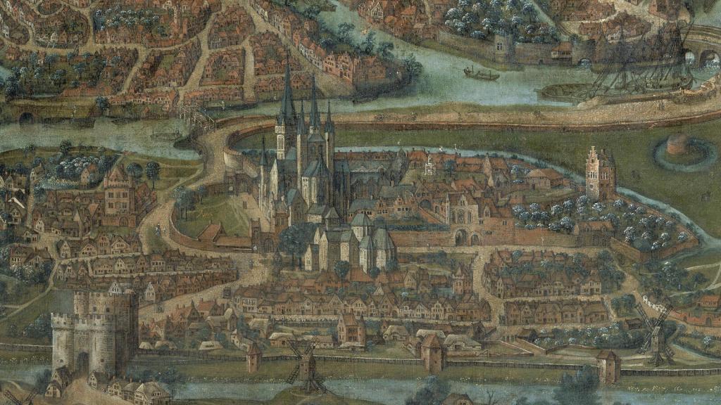
It is very plausible that the frontier Sincfala as mentioned in the Lex Frisionum, is a continuation of the administrative lay-out and network of the Roman Empire, and therefore of its provincial borders. According to Plinius, the River Scheldt was the border between the provinces Germania Inferior and Gallia Belgica. This must be understood as the wider delta of the River Scheldt and included inlet the Zwin. Probably the Roman provincial border, and that of Frisia later on, also ran between the town of Oudenburg to that of Bruges, whereby Bruges was part of Frisia as well. Bruges, connected with the sea via inlet the Zwin.
The River Scheldt was also the administrative border for Roman taxes, namely between the tax districts Trajectum (current Utrecht) and Gesoriacum (later Bononia, current Boulogne-sur-Mer). This administrative division was maintained by the early-medieval ecclesiastical organisation. Sincfala was under the jurisdiction of the archbishopric of Cologne, and thus of the bishopric of Utrecht. Therefore, it is logical that the Merovingian border between the Frankish kingdoms Neustria, the western kingdom, and Austrasia, the eastern kingdom, was defined by the previous Roman provinces (Zijlmans 2016).
The inherited administrative organisation of Rome might explain why two abbeys of Ghent so close to each other, only one and a half kilometres apart, had such a different orientation concerning their mission area. Ghent was located on the border of two pagi ‘districts’. And not only on the border of two pagi but also on that of German and French empires.
The Saint Bavo Abbey, at the confluence of the River Scheldt and the River Leie, is traditionally regarded as ‘Frisian’, whilst the Saint Peter’s Abbey as typical Frankish. The Saint Bavo Abbey focused on including and converting the Frisian people. It is after all the early-eleventh century Vita Bavonis confessoris gandavensis ‘The life of Saint Bavo of Ghent’ that mentions that Frisians, that is, those in West Flanders and Zeeland, are numerous and strong, but weak in their faith. From the eighth century, the Saint Bavo Abbey also possessed domains on the island of Walcheren in West Frisia (Henderikx 2021), and on the island of Zuid Beveland. We are informed about these latter possessions by a tenth-century charter of the Holy Roman Emperor Otto II (Van Steensel & Chamuleau 2021). Count of Flanders Robert I, known as Robert the Frisian (ca. 1035-1093), was prelate of the church of Saint Bavo.
Emperor Otto II (955-983) was, because of its strategic location, very committed to the Saint Bavo Abbey. Also his vassal Count Dirk II (ca. 932-988) of West Frisia, a brother-in-law of Count Arnulf I of Flanders, had close ties with the Saint Bavo Abbey. From this abbey, Dirk II had founded the abbey at Egmond in West Frisia, the modern province of Noord Holland. Not long before his death Otto II even acceded to its monastic community (De Maesschalck 2012). Incidentally, the fact that the Saint Bavo Abbey was more oriented toward Frisia, helps to understand why the Grote Kerk ‘great church’ in the town of Haarlem in the province of Noord Holland has Saint Bavo as its patron. Very appropriately, the Frisian statesman Wigle van Aytta van Zwichem (1507-1577), commonly known as Viglius, is buried in the church of Saint Bavo in Ghent, of which he was coadjutor abbot.
The church of Saint Bavo, by the way, was preceded by a smaller, wooden church founded in the late seventh century by the Anglo-Saxon missionary Saint Willibrord. A time when the entire province of Noord Holland was still called (West) Frisia. Today, you can only admire the ruins of Saint Bavo Abbey, just east of the town centre of Ghent. A metaphor, perhaps, for what happened to its cherished Frisia. Lastly, the site of the Saint Bavo might have been an early-medieval thing site as well (Tys 2018). See our blog post Well, the Thing Is… Speaking From the Moral High Ground of Old about the history of the medieval Germanic assemblies called the thing, also called ding or ting, with surprisingly quite a distinct role for the Frisians.
Close ties between West Frisia and Flanders existed also between the counts of both regions. In the year 1063, Robert the Frisian, or Roberto comite Frisone ‘Robert count of Frisia’ married Countess Gertrude, widow of the count of West Frisia. That was after Count Floris I of West Frisia was narrowly defeated by the bishops of Utrecht, Liège and Metz in 1061. In Flanders he was named Rodbrecht or Robbrechte de Vriese. The nickname ‘the Frisian’ he got already during his reign after he married Countess Gertrude of Saxony, widow of Floris I count of West Frisia (Nieuwenhuijsen 2022). Robert himself was count of Flanders, and, after his marriage with Gertrude, also regent of West Frisia for a while. After the battle of IJsselmonde in the year 1076 an army of Robert the Frisian and Count Dirk V, the son of Gertrude and first heir, defeated Bishop Conrad of Utrecht, after which Dirk V retook control over his West Frisia.
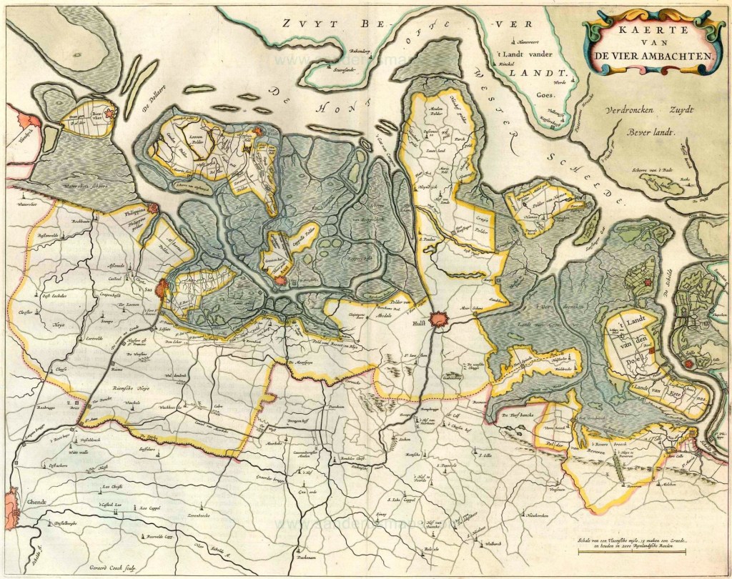
The centre and east of Zeelandic Flanders probably belonged to the jurisdiction of the Lex Frisionum as well. The Lex Frisionum as such gives no information how the border ran in eastern direction from Sincfala following the River Scheldt basin. This area of Zeelandic Flanders, which consisted of many islands, too, during the Early Middle Ages, became known as Vier Ambachten ‘four districts’. These were Assenede, Axel, Boekhoute, and Hulst. Early medieval law practices show traces of Old Frisian law in the Vier Ambachten, like the legal construct ferdban, or vredeban, and the obligation of hercogghe (Van der Tuuk 2007, Zijlmans 2016).
The legal construct of ferdban, by the way, lived on in the province of Friesland until the early sixteenth century. It was procedural law concerning the transfer of property. Any person who obtained a piece of land or real-estate, had to ask a skelta ‘judge’ for a so-called ferdban, literally translated as ‘peace decree’. This procedure meant the judge gave the opportunity for others to object to the transfer if she or he held a stronger right (Vries 2021). Indeed, speak now or forever hold your ‘ferd’ (‘fredus’, peace).
INTERMEZZO
Conscription in the Early Middle Ages (De Graaf 2004, Van der Tuuk 2007) — In early-medieval West Frisia, stretching from Sincfala in the south to the River Vlie in the north, what is now strait Vlie between the Wadden Sea islands of Vlieland and Terschelling, existed a system of mobilising boats and warriors in response of seaborn threats. The entire coast was divided into districts called a kog(ge) or cogge. The oldest attestation dates from the early eleventh century, namely kogcho. Each kogge had to provide a boat manned with warriors annex oarsmen when called upon, a so-called heervaart. The etymology of which is heer meaning ‘army’ and vaart meaning ‘to go/to sail’. This was also called a heerban ‘army obligation; providing an army for battle’. A heervaart was therefore also known as scipheervaerde or skiplede.
At the same time, a kogge was also the name for a flatboat type designed for navigating shallow waters, especially the Wadden Sea. No keel, for one thing. Thus, a typical Frisian boat type, with the valley of the River Rhine being the cradle (Westerdahl 1995). A boat type that can be traced back to the ninth century. It also is the predecessor of the famous high-medieval kogge or cog. The boat type that partly explains the success of the powerful Hanseatic League during the High Middle Ages.
A manned boat with oarsmen and warriors was called a heerkogge, with heer, as explained, meaning army. In the part of West Frisia what Zeelandic Flanders is today, and specifically in the district Vier Ambachten, it was called hercogghe. However, the custom of heerkogge was not known in the rest of Frisia, so east of the River Vlie. Perhaps because lack of a centralistic institutions strong enough to enforce the heerkogge. Or was it simply not needed along the Wadden Sea coast? Or, lastly, was the Wadden Sea the origin of maritime threats elsewhere along the coasts of the North Sea? 😉
Kogge districts were subdivided into smaller units called riem, meaning oar. Each riem had the obligation to mobilise one armed warrior annex oarsman. Persons under this obligation were called cokingi. In West Frisia a kogge was subdivided into twenty or thirty riemen. A man-o’-war carried, therefore, between twenty or thirty warriors. The sign to mobilise heerkoggen was (also) communicated with light beacons.
This defence organisation possibly dates to the fifth and sixth centuries, when piracy along the coasts was a scourge. A time when it was necessary to patrol the coasts during the summer, sailing season (Van der Tuuk 2007). According to others, not that old per se, and they suffice with saying the tradition dates back to the Carolingian era at least (Dijkstra 2011).
Besides the heerkogge conscription, a tax was imposed named cogsculd ‘cogge debt’ and collected by the bishopric of Utrecht. During the time Danish warlords ruled, on behalf of the Frankish king, over big parts of Frisia for most of the ninth century, they also relied on the heerkogge. A system familiar to them because a similar practice existed in Norway and Sweden. There it was called leidang or skipreiða, and the tax was called skeppslag. The skipreiða in southern Norway also functioned as a thing. These were assemblies to discuss besides matters of defence also other matters of mutual interest, like taxes (Ødegaard 2013).
In Anglo-Saxon England a similar system of conscription was called fyrd. In the region of Nordfriesland ‘North Frisia’ in the north of modern Germany, the toponym harde (compare Old English ‘hir(e)d’ household) possibly originates from it. Think of current districts Wiedingharde, Bökingharde, Westerharde, Karrharde, and Goesharde. Interestingly, there might also be a relation with the Old High German word herta meaning ‘by turns’ (Van Renswoude 2025). This would fit nicely with the conscription called hir(e)d and harde, as mentioned, and maybe with härad and herred in Sweden and Norway, respectively.
During the so-called Golden Age of the Dutch Republic, a kaag was flatboat for inland waterway transport, and also used for loading and unloading cargo ships leaving for or coming from sea (Doedens & Houter 2022). In the northwest of the region of Jutland in southern Denmark, still a boat type related to the Frisian kogge can be admired, namely the kaag. A kaag is a flatboat type that existed in the Netherlands until the nineteenth century, likewise. The kaag floating the waters of the shallow Limfjord today, is called a kåg. No coincidence there. Lastly, at Viking Age trading town Birka in modern Sweden, the toponym kugghamn, meaning kog harbour, possibly with its origin to these Frisian ships docking its harbour to do business (Westerdahl 1992).
Many centuries later, the authorities of the same coastal region imposed a system for rescue at sea that had many similarities with the old heerkogge. It was the States of Holland and West-Friesland of the Dutch Republic that ruled in the year 1768: “op ieder Zeedorp van deese Provinciën te doen onderhouden een Boot met al desselfs toebehoren mitsgaders een wagen, ter vervoeringhe van de Boot” (‘at every Sea-village in this Province shall maintained a Boat with all its equipment including a trailer, to transport the Boat’). These were rowing boats normally with twelve oarsmen, exactly the number of the Irish and Anglo-Saxon monks when they set sail to foreign lands to preach the Gospel, who rowed on high waves during storms to rescue sailors and crew in distress (De Haan 1976). In other words, the organization of the rescue services along the North Sea and Wadden Sea has very, very old parallels and roots.
In summary, the southern border of early medieval Frisia is a continuation of the Roman administrative organization. This border ran more or less from Ostend, Oudenburg, Bruges, Aardenburg to Oostburg, including all of Zeelandic Flanders up to where the River Scheldt makes a bend to the west at Antwerp. Later, this area would be organized in the pagi Flandrensis, Rodanensis, and Wasia.
One side remark on the border area of Sincfala. This looks fine on written parchment, but in practice the landscape was as volatile as water. Better yet, in such an ever-changing landscape it was hard to define what was land and water. Only think of the enormous chunks of land in western Zeelandic Flanders, namely the islands of Koezand, Waterdunen, and Wulpen which were consumed by the sea. Easily two hundred square metres of land, and what used to be habitation area of Frisians and North Sea Germanics. Thus, borders inescapably became diffuse as well in this watery mess called Sincfala.
3. Frisians moving in — sixth century AD
By the end of the Roman period, the environmental situation along the southern coast of the North Sea had stabilized. A period of a so-called ‘low-energetic’ sea had started and would last throughout most of the Early Middle Ages. A continuous, albeit slower rise of the sea-level made it possible that layer after layer of mineral-rich clay was deposited by the sea on the coast (Deckers et al 2012). The Flemish plain had become a tidal marshland landscape, comparable to the Wadden Sea coast in the Early Middle Ages. A coast of islands with barrier beaches and dune belts, sea inlets, mudflats, marshes, silt ponds, (more inland) peatlands, and streams and rivers disposing excessive rainwater from the interior. Of the former inlets of the Roman Period, only the bigger ones survived in Flanders, namely the Yser, the Reie, and the Zwin.
Supported by archeological research, we know that from the sixth century onward the coastal plain had become suitable for people to dwell again. It is from this period people started to settle (Loveluck & Tys 2006). Others, however, suggest colonisation of the Flemish salt marshes only started in the seventh century (Coen 2008), or in the eighth century (Van Dierendonck 2009, Lichtenberg 2011). Toponymic research indicates a core area of permanent settlement on the coastal plain between the Yser and the Scheldt during the Merovingian period (Deckers 2013). From the late seventeenth century onward also similarities in toponyms indicate close ties between the coastal plains of Flanders and England. Anyway, we propose a prompt parley between all these scholars before, god forbid, another century is added to the list.
According to a sixteenth-century Flemish origin saga, three Scottish monks named Guthago, Guidolf and Gillo, arrived at Knocken in Sincfala, somewhere between the seventh and eighth centuries. Three holy men to undertake ministry among the marsh people of the Zwin Region. Guthago was even of noble descent. Son of a king even, some say. When Guthago died he was buried where the village of Oostkerke is today. His loyal companion Gillo, also written Gillon, did not want to leave Guthago’s side, and chose to live as a hermit near his grave. Soon, miracles started to happen, and a chapel was built on his grave. Later the church of Saint Quentin was built on the grave. Notwithstanding this beautiful saga about Saint Guthago cum suis coming from the west, for the true founders from overseas we must face north. And a century before, as said, in the sixth century.
Note that more to the north in West Frisia, another Scottish monk made history. This was Saint Jerome who was killed by Vikings at present village of Noordwijk near the mouth of the River Old Rhine. His remains were placed in the prestigious Abbey of Egmond. See our blog post The Abbey of Egmond and the Rise of the Gerulfing Dynasty.
Besides archaeology and sagas with a broad timespan, the historic texts tell us one or two things too about who occupied West Flanders and when. The sixth-century poet Venantius Fortunatus wrote that the Merovingian King Chilperic I (ca. 539-584) of Neustria was feared by the Frisian and the Suebi tribes. Chilperic picked a fight with the Frisians probably because with the occupation of the coasts of West Flanders, Zeeland, and the Lower River Rhine, the Frisians controlled the trade via waterways to important Frankish centres of Cologne, Tournai, and Maastricht. Who knows the Frisians were levying tolls. Possibly, already during Chilperic’s rule the small coastal strip of West Flanders and Zeelandic Flanders were brought under Frankish control, but we do not know for sure. Also, in the vita of Saint Eligius, written by Bishop Audoin who lived in the seventh century, the Frisians and Suebi appear on the scene in West Flanders. The vita recounts: “But in Flanders and Antwerp, the Frisians and the Suebi, and other barbarians coming from the sea coasts or distant lands who had not broken the plough yet [i.e. who were still heathen], received him with hostile spirits and averse minds.” Apparently, Frisians and Suebi lived along the coastal plain of Flanders, and upstream the River Scheldt in the vicinity of Antwerp by the mid-sixth century (Lanting 2012).
An early submission of the Frisians south of the River Scheldt during the reign of the Frankish King Chilperic I, i.e., the pagi Flandrensis, Rodanensis, and Wasia, in the course of the sixth century, was followed by the submission under Frankish control of the bordering pagi Scheldeland and Maasland only between 687 and 695. In the year 689 or 690, the delta of the River Scheldt as such was brought under control of the Franks (Henderikx 2021). Obtaining control over the pagi Scheldeland and Maasland by maior domo Pippin of Herstal was probably not too difficult, because it is unlikely his adversary King Radbod had real sway over the area (De Langen & Mol 2021).
the terp dwellers
Habitation on the coastal plain of Flanders was not seasonal, as has been thought by scholars for a long time. It was a theory that was only abandoned fifteen years ago. The presence of surface pottery concentrations and coins dating between the fifth and early twelfth centuries, among other things, is the reason why this long-standing theory of seasonal occupation has been discarded. Settlement at the salt marshes of Flanders was already permanent from the sixth century (Loveluck & Tys, 2006). People settled on creek ridges and built terps to live on (De Jongh, 2014). Settlements on level ground are called Flachsiedlungen, like the ones in Uitkerksepolder near Blankenberge (Pype, 2002).
Terps are artificial dwelling mounds which you can find all along the southern shores of the North Sea. From the village of Leffinge in West Flanders to the (former) hamlet of Misthusum in the southwest of Jutland. Check the Annex of our DIY manual — Making a Terp in Only 12 Steps for loads of background on this terp-thing phenomenon. Although archaeological research into the terps of West Flanders is still modest, early-medieval occupation on terps has been proven at the terp of Leffinge-Oude Werf. This terp, just east of Leffinge, was occupied between 600 and 1100. There is also archaeological evidence of terp settlements at Leffinge itself, i.e. Leffinge-dorp, and at Bredene (Ervynck et al 2013). Another terp is the one at Ramskapelle, and we do not mean the local restaurant De Terp (see note below), but archaeological survey only recently started here (Verwerft et al 2017). Just like Leffinge, the radial pattern of the fields surrounding Dudzele also indicates a terp settlement. A pattern identical to terp villages like Marsum and Foudgum in the province of Friesland (Tys 2002). The onetime village of Mikhem, also written as Michem or Mikkem, was located on a terp situated on the banks of the inlet Old Zwin (De Langhe 1996).
But more terps are desperately waiting to be revealed and its content uncovered. The many terp, wi(e)rde, stelle, werve, and werf toponyms in West Flanders for sure indicate presence of an early-medieval terp culture familiar to the north of Germany and the Netherlands, but archaeological research still must separate the wheat from the chaff. Which of these mound toponyms are terps indeed, and which are fake? Interestingly, the Zwin Region in Flanders does not know wierde toponyms, except for Locwirde (also written Lockwierde) and Weerdenburg. However, werf toponyms in abundance in the Zwin Region: Barezeles Werf, Blevins Werf, Boenzacs Werf, Bogaerts Werf, Commerswerve (before Cumbingascure), Houtwerf, Litterssuerua (later Letterswerve, current Damme), Molenwerf, Muenickewerfven (later Monnikewerve), Oude Werf, Outvaarts Werf, Stekels Werf, Wallewerve, Werf (or Ramskapelle), Zuidwerf, etc. (Zwaenepoel et al 2016). By far, most of these toponyms are in the vicinity of the former municipality Dudzele, just north of Bruges.
Recent archaeological DNA research into a grave field with fifty-three skeletons found at the Flanders coast at Koksijde, near Nieuwpoort, has proven settlers with ‘northern Saxon DNA’ lived here between 650 and 750 (Larmuseau 2021). Because the (new) early-medieval Frisians basically were of Saxon origin, see our blog post Have a Frisians Cocktail! A Rich Composition about the Frisian DNA, we may call them Frisians just the same. Perhaps, scholars of the university of Louvain are still adjusting to this historical concept of ties with the sea scum from the Frisian lands. Interesting fact, one of the bodies had a coin placed near his mouth, possibly to pay the ferryman to ferry him to the netherworld. This is familiar with Procopius’ sixth-century description in his History of the Wars, about how people of this wider coastal region believed their souls were carried from there across the sea to England. Find out how in our our blog post Rowing Souls of the Dead to Britain — The Ferryman of Solleveld.
Interesting fact is also that a migration process with a many similarities of that to West Flanders occurred on the other end of Frisia, namely in the region of Nordfriesland south of Jutland (Denmark). From the mid-seventh century, Frisians settled and populated these near-empty, low-laying landscape. Here too, both terp, locally known as Wurt, settlements on the tidal marshlands and Flachsiedlungen on the elevated, sandy grounds developed. The settlements on these dryer geests were often located on the edge to the wetlands with access to navigable waterways (Majhczack 2021). This way the best of two worlds was combined. On the one hand, dryer sandy soils out of reach for the salty sea, (more) suitable for growing crops. On the other hand, the high biological productivity of grassy tidal marshlands, suitable for husbandry (Knol 2021). And, being connected with waterways and the wider world as well. Excellent opportunities to connect with the supra-regional trade networks.
So, although (possibly) a bit later than the colonisation of West Flanders, time and manner of the migration are fairly comparable. The Frisians apparently knew how to survive in these barren, salt and wet environments. When examining the historic texts, there is no evidence the terp dwellers of West Flanders came under any significant political control, and is therefore in line with the nucleon-like culture of the Frisians living on terps along the Wadden Sea coast (Loveluck & Tys 2006).
But who were these Flemish-Frisians?
the Smokers of Waterworld
The early-medieval pottery found in West Flanders, can be found all along the southwestern coast of Frisia, up to the Wadden Sea area (Van den Berg 2016). The inhabitants of West Flanders were clearly influenced by the material culture comparable to those in East England and Central Frisia (Lichtenberg 2011). Toponymic research also indicates close ties between the coastal plains of Flanders and England from the late seventeenth century onward. In fact, early-medieval placenames in the southern North Sea region share many features (Deckers 2013).
Also, the fact that the terp culture has been proven present in West Flanders, albeit to what extent must unfold in the years to come, is another argument that they were Frisians who expanded their presence and (political) influence southward, up to the area around Leffinge or maybe Nieuwpoort. Of course, merely along the narrow strip of soggy coastline, inlets, and islands, including the tidal marshlands south of the River West Scheldt in Zeelandic Flanders and Vier Ambachten.
Probably the early-sixth century settlers in what are today Zeeland, Zeelandic Flanders and West Flanders, were a mixed people originating from the wider southern North Sea area, but politically being Frisian. Born out of a piracy culture that had developed during Late Antiquity, see our blog post Our Civilization — It All Began With Piracy, and flooding the coasts like jellyfish plagues in summer time ruining your beach holiday. These Frisians mainly settled in the pagus Flandrensis, i.e., the western coastal plain of Flanders around Oudenburg, the pagus Rodanensis north of the pagus Flandrensis and covering the western part of what is today Zeelandic Flanders. Maybe pagus Isseretius likewise. We assume that (parts of) pagus Wasia was occupied with the same sea based lowlife. Inlet the Zwin lay within the Flemish-Frisian pagus Rodanensis and included the upcoming town of Bryggia ‘Bruges’ (Zijlmans 2016).
They were free proprietors (Tys 2002), part of a southern North Sea Germanic culture, who lived off wind, water, and trade (Zijlmans 2016). “A [maritime] dynamic cultural system that made sense in its own right and operated largely outside the homogenizing tendencies of major political [inland] centers of power” (Deckers 2017). Settled on riverbanks and tidal marshland, and traded on beaches on both sides of the English Channel and far beyond.
The network of trading and artisan settlements of these North Sea Germanics stretched from the northern Netherlands westward, through the river deltas of the Rhine, Meuse, and Scheldt, and into West Flanders and northern France. Between the seventh and ninth centuries, trading centers existed, from north to south, at Medemblik, emporium Dorestat, Walcheren, Antwerp, Bruges, Veurne, Iserae Portus, i.e., the mouth of the River Yser, Wissant, emporium Quentovic, and the River Seine. All the aforementioned sites were in existence between the seventh and ninth centuries. The evidence from settlements on the coastal edges of the English Fenlands, the estuaries of the rivers Humber and Thames, the dune belts of the English south coast, together with Frisia, including coastal West Flanders, suggests a permanently occupied, vibrant, and interconnected network (Loveluck & Tys 2006). Frisia and the Frisians were clearly part of this sea culture.
INTERMEZZO
Mead and Swords — Even the drinking habits of the coastal culture differed from the people living on the mainland. Early-medieval glassware can be divided into two types of drinking vessels: the stable and the unstable ones. Unstable glassware, like cone beakers, palm cups, and funnel beakers, cannot be put down and must be held in one’s hand while drinking. When comparing the glass assemblage of coastal markets and emporia along the North Sea, coast like Ipswich and Dorestat, with the glass assemblage of inland, archaeologists have found that unstable glassware is the preferred type of the coastal people (Broadley 2021). In other words, while inland people enjoyed a refined dinner and nipped their wine from a globular beaker placed on a set table, the boisterous, smelly scum of the sea, by contrast, were raising their palm cups filled with mead and shouted: “bottoms up!” Real Klaus Störtebekers, the legendary pirate of the Baltic Sea and the Wadden Sea in the late fourteenth century. A name meaning ’emptying a mug with one gulp’.
When looking at the modern drinking glass in the province of Friesland, called a fûgeltsje (‘little bird’), have things really changed ever since?
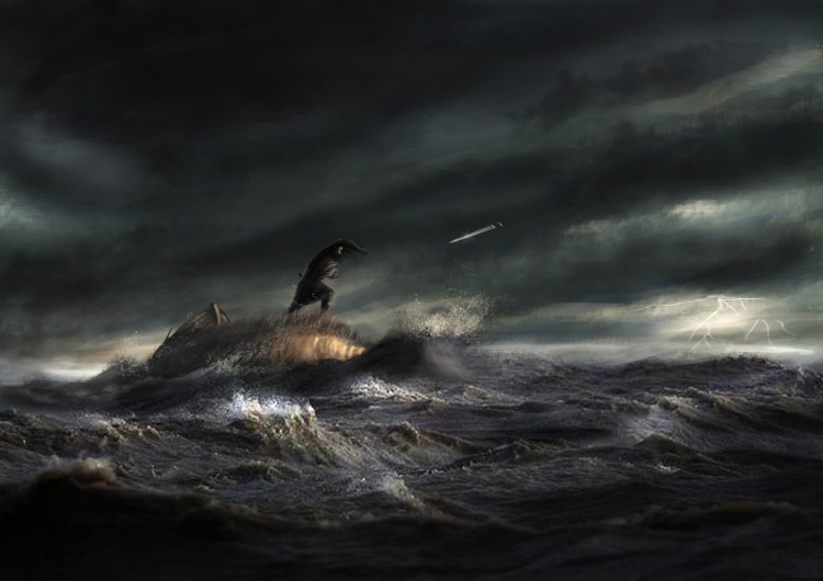
Another difference between coastal and inland culture which comes to the surface from archaeology, are rituals concerning swords. In the Early Middle Ages two types of deposition can be distinguished, namely depositions in graves and deposition in water. If you look at the differences between heathen Scandinavia and those of the Christian Frankish Empire in the Carolingian period, nearly all swords found in Scandinavia are grave founds, whilst swords found in the Frankish territory are mainly found in water (Maczek 2021). Especially along the north-western coast of Europe in navigable rivers, and even more specifically downstream of the rivers Loire, Seine, Scheldt, Rhine, Ems, Weser, Elbe, and Eider. Maritime Frisia firmly positioned in this Excalibur-in-water ritual. One exception, inland upstream the River Rhine near Koblenz, a concentration of river depositions has been found, too. Seemingly, all seven swords found in Belgium have been dug up from rivers. Mainly downstream the River Scheldt. At least twenty-eight out of the forty-two swords found in the Netherlands come from water as well. Most of these have been found in the central river area, including emporium Dorestat.
The reason for depositing swords into rivers might have been that rivers, which flow, were attributed the agency of washing away memory. Like the dead bodies of offenders, which were also thrown in the river to wash away sins and the community’s memory of this person. Another, also christian-inspired tradition, is that rivers were considered to be connected with the rivers flowing from Paradise (Arnold 2024). In the region of Westfriesland in the province of Noord Holland a saga exists about King Radbod whose sword Asbran must be returned to the spirits of the River Rekere. See our blog post Guerrilla in the Polder. The Battle of Vroonen in 1297 for more.
It seems, once the coastal people were christened and grave gifts had become a pagan, thus forbidden practice, they started to ritually deposit their precious swords in important waters. This phenomenon did not take place in Scandinavia. Perhaps because people remained a bunch of not-so-cozy pagans for a while longer.
The coastal landscape, especially the tidal marshland offered only limited, albeit productive, economic possibilities. These were especially livestock of cattle and sheep, and thus meat, dairy products, leather, and wool. Check our blog post Come to Rescue ‘The Rolling Sheep’ for an overview of economic possibilities of sheep. But also, the production of salt, extracted from the sea or from peat. The limited variety of natural resources of the marshland, including quite essential products like wood, crops, grains, stone, and even sometimes sweet water, meant this sea culture had to trade. By no means it could be fully self-sufficient. Thus, the Frisians needed to be connected to waterways, rivers, and seas to have access to the missing products.
It immediately brought an advantage. Contrary to communities further inland, coastal community had open access to all kinds of other products, including to the most luxurious and exotic stuff of the era. They even transported the stuff. This was very relevant in the gift-exchange culture of the Early Middle Ages. “Such a degree of access on the part of, often modest households, put coastal dwellers outside the social norms and relations reinforced by access to imported commodities, within settlement hierarchies away from the coasts. The simple fact appears to be that a broader social spectrum of coastal societies had access to a greater quantity of imports than contemporaries inland, even if the sites of exchange were overseen by local royal officers” (Loveluck & Tys 2006). And, the coastal zone of Frisia from Jutland to the delta of the River Rhine in early-medieval time, and the Zwin Region with Bruges in high-medieval times, was the crossroad of European and Mediterranean trade traffic (Westerdahl 1992). In sum, a strategic spot.
Flemish broadcloth
One of the products the Frisians manufactured themselves mentioned briefly already, deserves more attention since it became world famous, namely the Frisian cloth called pallia Fresonica or simply Fresum. The pallia Fresonica was highly valued in north-western Europe (Tys 2002). It is made of wool and therefore sheep husbandry was an important economic activity all over Frisia in the Early Middle Ages. From historic documents we know that wool and broadcloth production was the most important locally fabricated product in coastal Flanders during the Carolingian period (Deckers et al 2012). For example, we know that King Childebert IV (694-711) donated mariscos duodecim ’twelve marshlands’ which were in the pagus Rodanensis to the Saint Peter Abbey in Ghent in the year 707 already. These mariscos ‘marshlands’ were used for grazing sheep. The abbey also received a marisco at Greveninge in 757, and a marisco at Cumbingascure in 794. For a more in-depth story on the pallia Fresonica, see our blog post Haute Couture From the Salt Marshes. Later, in the High Middle Ages, when Flanders production of broadcloth went through the roof, wool production in Flanders itself could not keep up the demand, and thus wool needed to be imported from the British Isles.

Today, Flanders is still remembered for its medieval broadcloth or ‘Vlaams laken’. It was an important pillar of its wealth and power during the High Middle Ages. Bruges would become one of the most powerful and creative cities of Europe (Trachet 2018). Ieper and Ghent also developed into broadcloth producing cities in the ninth and tenth centuries. Wool and sheep are therefore deeply engraved in the psyche of the Fleming. Not without reason we like to think that the altarpiece painted by Hubert and Jan van Eyck between 1420-1432, was named the Adoration of the Mystic Lamb. A piece so significant, it is considered world heritage.
Sheep farming is still a distinct feature of the landscape of the coast what used to be Frisia. From West Flanders to southern Jutland you can see the white fluffy animals with their alien eyes grazing, ruminating and bleating everywhere. On dikes, embanked lands, laying on the warm asphalt road, blocking your way, and sometimes to be admired on tidal marshlands still. Sheep, namely, can handle a salty environment well. Today, the Wadden Sea island of Texel in the province of Noord Holland is still famous for its sheep’s race. The Texel sheep carries that much wool, that when it accidently rolls on its back, it will never be able to get on its feet again. If not helped, it simply dies. Please, memorize our blog post Come to Rescue ‘The Rolling Sheep’ how to assist a sheep laying on its back. Essential for hikers of the Frisia Coast Trail. Also, to this day the region of Ostfriesland is preoccupied with sheep. It considers it even its national mascot.
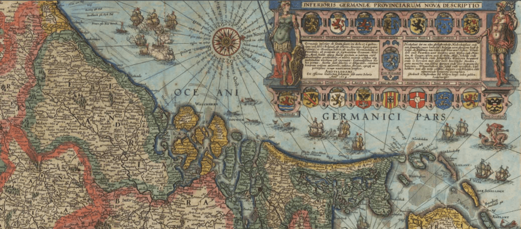
the Zwin and Bruges
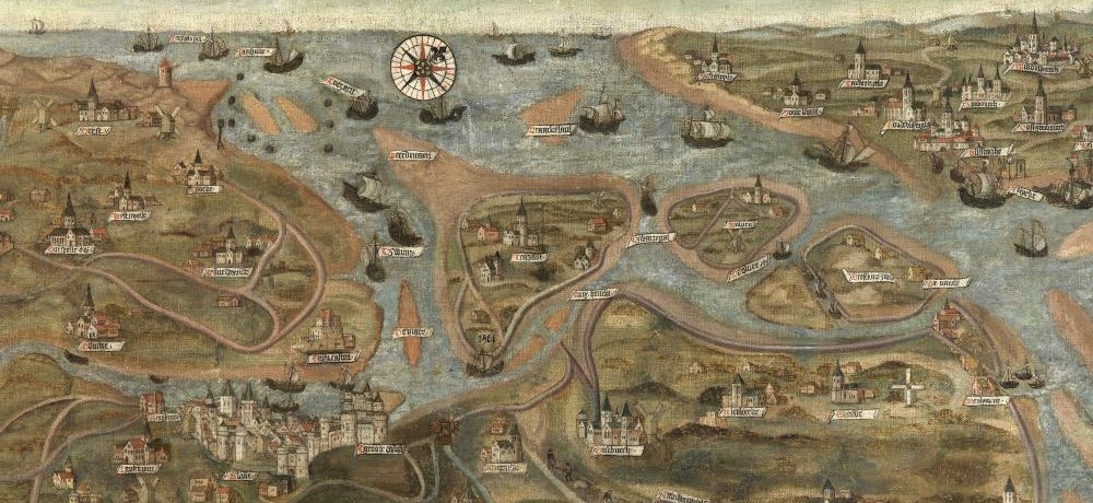
Since the Zwin is identified with Sincfala, and because the inlet was the foreland of one of the most prestigious cities of Flanders and the world, namely Bruges, we must elaborate a bit on its history. The Zwin Region, of which inlet the Zwin is part, encompasses the municipalities Damme, Knokke-Heist, Maldegem, Sint-Laureins, Dudzele, Lissewege, and Zeebrugge in West Flanders, and the municipality Sluis in the Netherlands. Furthermore, inlet the Zwin of today gives you a glimpse of how the Flanders’ coast looked like in the Early Middle Ages. A row of dunes breached by an inlet, creating an inland area of barren, tidal marshlands. Inlet the Zwin is a nature reserve since 1952 already. In 2019, the so-called Internationale Dijk ‘International Dike’ has been excavated to give inlet the Zwin more space and enlarging the surface of tidal marshlands.
The sea inlet was created during the first centuries of the common era. By the Early Middle Ages, after sea activity had quieted down, inlets along the Flemish coast slowly started to silt up. This was also the case with the Zwin. Furthermore, sheep husbandry had also been a long-standing economic activity in the Zwin Region. Shepherds have been active in the Zwin Region for an amazing period, from the eighth until basically the eighteenth centuries (Zwaenepoel & Vandamme 2016). Sheep shepherds active in the area today are Koen Pille and Carola van den Handel. They stepped into the footsteps of Sam Duysan and Frans Dullaert (CAG website).
Bruges was strategically located at the point where three districts came together, namely the pagus Flandrensis, the pagus Rodanensis, and the pagus Mempiscus. And, it was connected to the North Sea. The name became Bruges and might stem from the Old Dutch word brugga ‘bridge’. Originally, Bruges was connected with the sea via the inlet Blankenberge and the stream Reie. Inlet Blankenberge silted up in the tenth century. After this, a canal was dug to connect Bruges with the channel Old Zwin, and this way being reconnected with the sea again. Soon after, also the Old Zwin started to silt up. The silting-up process kept them busy. Relief came in the first half of the twelfth century with several great floods hitting the coast hard, but deepening existing sea inlets at the same time. Especially the great flood of October 1134 had major impact on the landscape. In the words of Jacques Brel: “Wanneer de noordenwind de vlakte vierendeelt” (‘When the northern wind quarters the flat’), although western winds in general are more threatening. A new navigable channel was created after the great flood had reshaped and deepened the small channel Budanvliet or Budanflit. This became the Zwin proper. Channel Budanvliet ran a bit more to the south, parallel to the Old Zwin (Dumolyn et al 2016). By the way, after the creation of the Zwin proper, still a canal of fifteen kilometres had to be dug to connect Bruges with the (new) Zwin at Damme.
Along the Zwin several port towns developed during the late twelfth and thirteenth centuries, namely Hoeke, Letterswerve (later Damme), Lamminsvliet (later Sluis), Monnikerede, and Mude (later Sint-Anna-ter-Muiden). It became a portuary network, but all dominated by the powerful city of Bruges. Once Bruges’ hegemony came to an end and the Eighty Year’s War commenced, Hoeke, Monnikerede, and Mude (nearly) ceased to exist (Tranchet et al 2016). The towns of Damme and Sluis survived as fortified cities during the many wars.
Mid fifteenth century is generally marked as the end of the hegemony of Bruges. Inlet the Zwin had silted up. Yes, again. A process this time further stimulated because of cultivating the wetlands in the Zwin Region. Much of the Zwin Region was embanked with innumerable dikes from the tenth century onward, and with monasteries, churches and feudal lords being the driving forces behind this cultivation. Dikes, however, had a counterproductive effect when it comes to keeping inlet the Zwin navigable. Effect of embanking the floodplain of the Zwin meant less sea water can enter the valley and therefore reducing the force of the sea inside the inlet, leading to more sedimentation and thus net growth of land (Wintein 2003). A similar process happened in the valley of the River West Scheldt once the river forelands were embanked there too. Otherwise, Belgium and the Netherlands have a smooth cooperation dredging the River West Scheldt to keep the harbours of Antwerp accessible. Really, they have. Smooth, really.
Furthermore, concerning the decline of Bruges, the region of Holland and the British Isles had become strong competitors in the production of high-quality broadcloth, respectively around 1400 and 1500. On top of this, in the second quarter of the fifteenth century Holland cracked down the supremacy of the Hanseatic League and Amsterdam was racing unstoppable to pole position in global sea commerce. See our blog post Yet Another Wayward Archipelago — The Wadden Sea on how things developed in and after the Late Middle Ages. Lasty, in its struggle for independence, the Dutch Republic had turned West Flanders into a big war zone with Spanish, French, and any other European army for that matter.
4. Danes moving in — ninth century AD
After two previous arranged marriages with successively the Anglo-Saxon kings Aethelwulf and her stepson Aethelbold, both who died soon after marriage, Judith must have thought: “Enough is enough”. She took matters in her own, capable hands (or had she already?). In the year 862, she flees from the monastery in Senlis where she had been locked up by her father, and secretly marries a certain bloke named Baldwin. Her father, the illustrious Charles the Bald and king of West Francia, was, to put it mildly, outraged. The newlyweds had to find shelter to sit out her fathers’ rage. The Danish warlord Rorik of Dorestad, who ruled over his benefice West Frisia at the time, offered them refuge. They kindly declined Rorik’s offer and accepted a similar offer from King Lothar II of the Kingdom of Middle Francia. By now, Charles was really out of his mind. Secretly marrying and then staying at the house of his rival.
Captain Smith and Pocahontas
Had a very mad affair
When her Daddy tried to kill him
She said, “Daddy, oh don’t you dare”“He gives me fever with his kisses
Fever when he holds me tight
Fever, I’m his missus
Daddy won’t you treat him right?”
lyrics Fever (Peggy Lee, 1958)
Finally, Charles forgave his daughter. He made a margrave of the Baldwin kid and gave him the watery mess of West Flanders. An area infested with Vikings at the time. Judith gave birth to Baldwin II and arranged a marriage with Aelfthryth, the daughter of the King Alfred the Great, king of the West Saxons. Margrave Baldwin II (879-918) became the first powerful ruler of Flanders. Also his successor, Count Arnulf I, is considered a powerful ruler who expanded the territory. The saying is hard times create strong men. These were hard times, indeed. Nevertheless, when it comes to the origin of the county of Flanders it all started with a decisive woman, named Judith.
The first Viking raid at the Frankish Empire was in the year 810. With a fleet of two hundred ships they attacked the north of Frisia, somewhere at the Wadden Sea coast, and placed the Frisians under tribute. Charlemagne immediately reorganised the coastal defence, and this kept the Vikings at bay for a while. But between 834 to 839 Frisia was regularly pillaged, including the trading towns, Antwerp, Dorestat, the island of Walcheren, and Witla (Heeringen 1998). The island of Walcheren was attacked in 837 and defended by, interestingly, a Danish commander by the name Halfdane Hemming. See our blog post Walcheren Island. Once the Sodom and Gomorrah of the North Sea about this attack. From 841 to 885, the so-called prefecture West Frisia was given as benefice to Danish warlords. First to Rorik of Dorestad, and after his death to Godfrid the Sea-King. This Frankish strategy was effective because the raiding of Frisia did come to a halt.
Around the year 850 Arabs introduce the game of chess in Spain. It was however also from 850 onward that Vikings started harassing Flanders intensively, especially penetrating the region via the River Scheldt. In 851 they set fire to the ‘Frisian’ Saint Bavo Abbey in Ghent. Things really worsened in July 879. The year before, at the Battle of Edington, the Great Heathen Army was finally defeated by the Anglo-Saxons, which resulted in the Treaty of Wedmore. After the defeat in 878, the Scaldingi chapter of the Great Heathen Army returned to its former base, the estuary of the River Scheldt in West Frisia. From there they started raiding the Flemish coast and the Upper River Scheldt. Maybe using the island of Walcheren as base for foraging and to supply the raids inland. Several times the Vikings even wintered in Flanders. It was King Arnulf of Carinthia who defeated the Vikings in a final battle at Louvain in the year 891. The same Arnulf, by the way, who had before an army of Frisians driven out the Vikings from East Frisia at the Battle of Norden in 884, and the same Arnulf who had Godfrid the Sea-King assassinated in 885 and his warband defeated by a combined army of Saxons and Frisians at Spijk near Emmerich.
A major innovation of the Franks to keep the Vikings out, was building a network of fortresses. The Annales Bertiniani speaks in the year 891 of castella ibi recens facta ‘recently built castles’. Archaeological research confirms that from the last quarter of the ninth century all along the southern coast of the North Sea so-called ring fortresses were built — also known as Ringwallanlage, Wallanlogen, or ringwalburcht. Many of them in West Frisia, with quite a concentration of forts in what is now the region of West Flanders and the province of Zeeland. Already three fortresses, at least, at the island of Walcheren. These were circular fortresses consisting of an earthen wall with a palisade on top, and with a ditch around it. The diameter of these fortresses varied but reckon easily about two hundred metres.
Perhaps, the Frankish kingdom followed the recent example of King Alfred the Great of Wessex who had also built a network of castles or burhs to resist the Vikings and to strengthen his control over Wessex. Although, his castles were made of stone. A commodity which is scarce along the coasts of Frisia. Who knows, the resolute behaviour of Judith lay the foundations for this military knowledge and the so-called ‘burghal hidage’ policy of King Alfred (Tys 2018). It was probably the meiers ‘bailiffs’ and lords of royal domains and the domains of the abbeys of Echternach (Luxembourg) and Saint Bavo in Ghent who were governing the island of Walcheren, and consequently organized the raising of circular fortresses (Henderikx 2021).
Notwithstanding the ring fortresses on the Continent were constructed during the Viking Age and several can be found in Denmark, too, it is a general misconception these fortresses were Viking-build. Instead, these fortresses were a (also) successful strategy in defeating the Vikings. At the same time, these fortresses were crucial to wield military and political control over the maritime society of West Flanders. Especially, Baldwin II and Arnulf I might have invested in these fortresses. This way a centralistic, feudal power could be created successfully (Tys 2018). Albeit a bit later, the same principles were applied in West Frisia, where many fortresses have been built. However, this tactic never took root in Frisia along the Wadden Sea coast. Here the so-called Frisian Freedom would last another five centuries, until the end of the fifteenth century. However, it just so happens that in this region no archaeological proof exists of early-medieval fortresses.
Innovations in the North Sea coastal area, were not a one-way street. If the Franks learned to construct fortresses from English, the English learned from the maritime Frisians how to raise a naval fleet. From the Anglo-Saxon Chronicle, the year 896, we know that King Alfred of Wessex had Frisians help him to design a new type of long warship, and that he had Frisian warriors man his fleet as well. Also, this knowledge exchange might have been facilitated by the marriage of King Alfred’s daughter Aelfthryth with Margrave Baldwin II of Flanders (Williams, Smyth & Kirby 1991). See our blog post ♪ They Want You as a New Recruit ♪ for more details on Frisians and building and manning English naval fleets.
5. Conclusion
What about the Flemish-Frisians? Well firstly, most of it is still unclear. Especially since archaeology in West Flanders has much work to do. Research into the terps of West Flanders is fairly limited hitherto. But the picture is that when at the end of the Roman period Germanic tribes moved south, including Frisians (called Frisii or Fresones by the Romans). They probably also migrated to England, leaving behind their terps along the Wadden Sea after almost a millennium of occupation. The landscape, except for some small pockets of habitation, depopulated completely between ca. 325 and ca. 425. The end of the Roman period and the period of the Wandering of Peoples that followed, is also a period when a North Sea Germanic culture is being formed, partly born out of large-scale seaborn raiding. A maritime culture that begins to occupy the coastal zones of the North Sea, and on both sides of the English Channel.
The empty salt marshes of the Wadden Sea were re-populated in the fifth century, by a people that would be named Frisians again. These (new) Frisians were probably an admixture of (mainly) Saxons, Angles, and southern Scandinavians, together with some original Frisians in surviving pockets of habitation, and with some (old) Frisians remigrating from the current provinces of Noord Holland and Drenthe. See also our blog post Have a Frisians Cocktail! A Rich Composition for more information on these migrations. From the heartland at the southern coast of the Wadden Sea they first expanded south, all the way to the watery mess of West Flanders. That was in the early sixth century. In the seventh century, again from the heartlands at the Wadden Sea, they also expanded north, to the region of Nordfriesland, and also there populated the nearly emptied marshlands.
Political Frisia was, according to the Lex Frisionum, limited to an area with Sincfala as its southernmost border and the River Weser as its northernmost border, and mainly the strip “zwischen meer und moor” (‘between sea and peat’) as they say in Ostfriesland. Political, since here the laws of the Frisians held jurisdiction. In West Flanders and Zeelandic Flanders the Frisian presence was limited to only a small fifteen kilometres wide coastal strip, from more or less Leffinge or even from Koksijde near Nieuwpoort, all the way to where the Flemish-Frisian terp culture reached the region of Vier Ambachten, with Bruges probably just within the jurisdiction of West Frisia. The Frisians brought with them the maritime culture. A culture quite different from the inland, and one without central rulers, quite individualistic, and with extensive, overseas trading networks along the North Sea coast and at river mouths. Products they manufactured or produced were especially dairy, leather, salt, and woollen cloth. At least from around 600, they started building terps in West Flanders as well.
Linguistically traces of the old Frisian coastal speech can be identified in especially place names. The element muide(n) is an old Frisian form related to the English word ‘mouth’ and denotes the mouth of a waterway. The Dutch word is different, namely mond(e) (Kerkhof website). The toponym muide(n) can be found along the wider Flemish and Dutch coastal area, like the place names Diksmuide, the already mentioned Sint-Anna-ter-Muiden, and the different Muide toponyms in the town of Ghent, all in the region of Flanders, and Arnemuiden, Cellemuiden, Muiden, IJmuiden, IJsselmuiden, Genemuiden, Leimuiden, and Zuidmuider in the Netherlands. In the ninth century the Flemish coast switched from the Frisian to the Dutch language.
The Frankish kingdoms probably were able to have their influence over this maritime culture of (Zeelandic) Flanders south of the River West Scheldt in the course of the sixth century already, albeit much is still very uncertain concerning the relationship between the coastal Flemish-Frisians and the continental Franks in this region. The early supremacy of the Franks, together with the arrival of the Vikings, and worsening natural living conditions along the Flemish coast, caused the Frisian identity south of the River Scheldt to vaporise relatively quick. As would happen not long after with the Frisians in the province of Zeeland as well. Consider also, that in the ninth century the difference between Frisians and Vikings was not very sharp defined. Besides being physically neighbours, both originated from the same Germanic maritime culture, both were (still) heathen and shared the same concepts, and both were heavily interconnected in trade and, yes, also in raiding operations, as we have seen.
This story also illustrates that the history of the coast which once was political and cultural Frisia, i.e. the area from West Flanders up to the region of Ostfriesland, is an intriguing one. One that did not stay unnoticed in world history, despite lacking great kings and emperors. Firstly, the early-medieval Frisians were forerunners in introducing free trade and economic liberalism. Being innovative in means of transport, ship building (cog ship) and the money economy. See our blog post Porcupines Bore US Bucks. The Birth of Economic Liberalism to learn more how capitalism was introduced to the world. Secondly, in the High Middle Ages, it was Flanders that picked up the baton from Frisia and developed into the cultural and economic leading region of Western Europe and way beyond. Very much connected with that other trade network, the Hanseatic League from northern Germany and the so-called free cities of Hamburg, Altona, and Bremen. Lastly, in the course of the fifteenth century, Flanders was succeeded by what would become the Dutch Republic, with the three coastal provinces of Zeeland, Friesland, and, especially, Holland taking the lead. It led to the first successful bourgeois revolution in the world.
The history of this region has several things in common. Among other, it is not perse a history of great kings, feudalism, imperialistic wars, and of imposing the Christian faith. Rather, it was more defined by individualism, weak central structures, a high level of urbanisation, and above all by businessmen making money through inter-regional trade.
All that, in a very dynamic, narrow strip of Sincfala, stretching much further than West Flanders alone. An endless strip of watery mess, in fact, which carries Frisia as its overarching, ancient name.
Note — The dish Waterzooi. We translated waterzooi as ‘watery mess’. That is what it literally means in modern Dutch speech. Its etymology is a different, though. The component zooi derives from the Middle Dutch verb sode and comparable to the current Mid Frisian verb siede. Both meaning ‘to boil’. Optional, since no recipe is the same, ingredients of the dish are: fish, potatoes, butter, celery, carrot, onion, leek, fish stock, egg yolk, cream, chives, salt, and pepper. Fish is the classic, but waterzooi of chicken (stock) gains ground. If you are not a Wout Bru yourself, make reservations at a restaurant. Perhaps the owners of restaurant De Terp in Ramskapelle (Knokke-Heist) in West Flanders are willing to fix you a tasty bowl with this watery mess. Or they might extinguish their barbecue with it…
Suggested music
- Brel. J., Mijn vlakke land (1962)
Further reading
- Abernethy, S., Judith of France, Queen of Wessex and Countess of Flanders (2015)
- Adams, D., The Hitchhiker’s Guide to the Galaxy (1979)
- Arnold, E.F., Medieval Riverscapes. Environment and Memory in Northwest Europe, c. 300-1100 (2024)
- Berg, van den B., Migranten of Passanten? Scandinavische vestiging in negende-eeuws Frisia (2016)
- Bervoets, G., Gentse waterzooi. Een culinaire ontdekkingsreis rond de wereld (2000)
- Bolhuis van Zeeburgh, J., Kritiek der Friesche geschiedschrijving (1873)
- Booth, H., North Sea Nexus. At the mercy of shifting sands. Bruges, Dunwich, and the dynamic seabed (2025)
- Bracke, W. & Leenders, E., Vlaanderen in 100 kaarten (2015)
- Bremmer, R.H., “Thi Wilde Witsing”: Vikings and Otherness in the Old Frisian Laws (2020)
- Broadley, R., Glass vessels from the early medieval emporium Ipswich (2021)
- Bruce-Mitford, R., Ships figure heads in the Migration Period and Early Middle Ages (1970)
- Buisman, J. & Engelen, van A.F.V. (eds.), Duizend jaar weer, wind en water in de Lage Landen. Deel 1. Historisch onderzoek 764-1300 (1995)
- Centrum Agrarische Geschiedenis (CAG) Collectie Bulskampveld, Herders in de Zwinstreek (website)
- Charlier, R.H., The Zwin: From Golden Inlet to Nature Reserve (2010)
- Claerhout, J., De Franken, de Friezen en de Saksen. Onze voorouders (1886)
- Clement, C. et al (eds.), Terra Incognita. Annual Review of Archaeological Master Research in Flanders (Belgium). Academiejaar 2008-2009 (2012)
- Clerinx, H., De god met de maretak. Kelten en de Lage Landen (2023)
- Clius, V., De Gentse Sint-Baafsabdij, parel uit het verleden (2016)
- Coen, I., De eeuwige Schelde. Ontstaan en ontwikkeling van de Schelde. Waterbouwkundig laboratorium 1933-2008 (2008)
- Coulthard, S., A Short History of the World According to Sheep (2020)
- Coornaert, M., De Delta van de Zinkval (1991)
- Deckers, P., A toponymic perspective on the early medieval settlement of the southern North Sea shores of mainland Europe (2013)
- Deckers, P., Cultural Convergence in a Maritime Context. Language and material culture as parallel phenomena in the early-medieval southern North Sea region (2017)
- Deckers, P., Ervynck, A. & Tys, D., De vroegmiddeleeuwse bewoning van de kustvlakte: de terpsite Leffinge — Oude Werf (2012)
- De Clercq, W., Dombrecht, K., Dumolyn, J., Leloup, W. & Trachet, J., Monnikerede: The Rise and Decline of a Medieval Port Community in the Zwin Estuary (2020)
- De Clercq, W., Trachet, J., Poulai, M. & Ruijsscher, de D., Een archeologische evaluatie, waardering en ruimtelijke afbakening van de verdwenen Zwinhavens Hoeke en Monnikerede (gemeente Damme, provincie West-Vlaanderen) (2018)
- De Graeve, A., Het vergeten deel van de collectie Maertens de Noordhout boven water gehaald. Studie naar de vroegmiddeleeuwse rivierdeposities in de Scheldevallei (2010)
- De Keyser, R., Sint Guthago te Oostkerke (1957)
- De Maesschalck, E., De graven van Vlaanderen (861-1384) (2019)
- Devinck, F. & Lannoy, D., Keltische oorsprong in een Germaans daglicht gesteld (2009)
- Dhaeze, W., The Roman North Sea and Channel Coastal Defence. Germanic Seaborne Raids and the Roman Response (2019)
- Dierendonck, van R.M., The Early Medieval Circular Fortresses in the Province of Zeeland, The Netherlands: Ten Years After (2009)
- Dijkstra, M.F.P., Rondom de mondingen van de Rijn en Maas. Landschap en bewoning tussen de 3e en de 9e eeuw in Zuid-Holland, in het bijzonder de Oude Rijnstreek (2011)
- Dillen, K., Porpoise, punishment and partnership: the meaning of presenting and consuming a marine mammal in late medieval coastal Flanders (2021)
- Doedens, A. & Houter, J., Zeevaarders in de Gouden Eeuw (2022)
- Dumolyn J. & Leloup W., The Zwin estuary: a medieval portuary network (2016)
- Ervynck, A., Deckers, P., Lentacker, A., Tys, D. & Neer, van W., Leffinge — Oude Werf: the first archaeozoological collection from a terp settlement in coastal Flanders (2012)
- Evans, N. & Jenkinson, A., What’s cooking in Belgium? Recipes and stories from a food-loving nation (2012)
- Freriks, K. & Storms, M., Grensverkenningen. Langs oude grenzen in Nederland (2022)
- Graaf, de R., Oorlog om Holland, 1000-1375 (2004)
- Heeren, S., From Germania Inferior to Germania Secunda and beyond. A case study of migration, transformation and decline (2017)
- Heeringen, van R.M., The Construction of Frankish circular fortresses in the province of Zeeland (SW Netherlands) in the end of the ninth century (1998)
- Henderikx, P.A., Walcheren en de Vita sancti Willibrordi van Thiofried van Echternach (2021)
- Henstra, D.J., Friese graafschappen tussen Zwin en Wezer. Een overzicht van de grafelijkheid in middeleeuws Frisia (ca. 700-1200) (2012)
- Hillewaert, B., Verdwenen bewoning te Michem (1985)
- Hines, J. & IJssennagger-van der Pluijm, N.L. (eds.), Frisians of the Early Middle Ages; Majchczack, B.S., Recent developments in early-medievalsettlement archaeology: the North Frisian point of view; IJssennagger-van der Pluij, N.L., Structured by the sea: Rethinking maritime connectivity of the Early Middle Ages; Langen, de G. & Mol, J.A., Landscape, trade and power in early-medieval Frisia (2021)
- Hollevoet, Y. & Roeyen, van J.P., Germanic Settlers at Sint-Gillis-Waas? (1992)
- IJssennagger, N.L., Central because Liminal. Frisia in a Viking Age North Sea World (2017)
- Jongh, de I., Romeinse en Vroegmiddeleeuwse Bewoning in de Vlaamse Oostkust. Predictieve modellering getoetst op bewoningslocaties in een dynamisch kustlandschap tussen 0 en 1000 CE (2014)
- Kerkhof, P.A., Van Fries naar Hollands (website)
- Koning, de J., De betekenis van Noord-Holland binnen vroegmiddeleeuws Frisia (2012)
- Kuiper, W., Tussen de Elven ende de wat? (2013)
- Kuipers, J. Encyclopedie van Zeeland; Het Zwin (2020)
- Knol, E., For Daily Use and Special Moments: Material Culture in Frisia, AD 400-1000 (2021)
- Langen, de G. & Mol, J.A., Landscape, Trade and Power in Early-Medieval Frisia (2021)
- Langhe, de J.E., Wat betekent de plaatsnaam Mikhem of Mikkem? (1996)
- Lanting, J.N. & Plicht, van der J., De 14C-chronologie van de Nederlandse pre- en protohistorie VI: Romeinse tijd en Merovingische periode, deel A: historische bronnen en chronologische thema’s (2010)
- Leloup, W. & Vannieuwenhuyze, B., Damme en Sluis: de oorsprong en vroege stadsontwikkeling van twee middeleeuwse Zwinstadjes (2013)
- Lichtenberg, L., Nieuw Verhaal over Oudste Historie van Brugge & Omstreken (2011)
- Loveluck, C.P. & Tys, D., Coastal societies, exchange and identity along the Channel and southern North Sea shores of Europe, AD 600-1000 (2006)
- Maczek, D., Non-funerary sword depositions in Carloningian Europe (2021)
- Nieuwenhuijsen, K., Living History Studies; Lex Frisionum (website)
- Nieuwenhuijsen, K., Robrecht de Fries. Graaf van Vlaanderen, held van Holland (2022)
- Nieuwhof, A., 650 Terpen langs de Noordzee (2018)
- Nieuwhof, A., The Frisians and their pottery: social relations before and after the fourth century AD (2021)
- Ødegaard, M., State Formation, Administrative Areas, and Thing Sites in the Borgarthing Law Province, Southeast Norway (2013)
- Popkema, A.T. (ed.), Fon jelde. Opstellen van D.J. Henstra over middeleeuws Frisia; Henstra, D.J., Weergeld in de Friese landen. Hulpmiddel bij de datering van teksten uit middeleeuws Friesland (2010)
- Port of Zeebrugge (website)
- Renswoude, van O., De groene gavers in het Vlaamse landschap (2026)
- Renswoude, van O., De herde (2025)
- Rossum, van H., Glass of the Middle Ages 5th to 15th century (2018)
- Roymans, N., Heeren, S. & De Clercq, W., Social Dynamics in the Northwest Frontiers of the Late Roman Empire. Beyond decline or transformation (2017)
- Steensel, van A. & Chamuleau, B., Water, land en dijken. Het ontstaan van middeleeuws Noord-Beveland (2021)
- Stevens, L.C., The Lovers (1956)
- Tavernier, R. & Ameryckx, J., Kust, Duinen, Polders (1970)
- Toorians, L., Etymologica: een nieuwe verklaring voor ‘Vlaanderen’ (2021)
- Trachet, J., Grandioos Grensgeval. Nieuw onderzoek naar het zestiende-eeuwse landschap op Pieter Pourbus’ geschilderde kaart van het Brugse Vrije (2019)
- Trachet, J. & De Clercq, W., Verdwenen haven sites in een verzwonden havennetwerk. Resultaten van vijf jaar onderzoek in de Zwinstreek (2018)
- Trachet, J., Delefortrie, S., Dombrecht, K., Dumolyn, J., Leloup, W., Thoen, E., Meirvenne, van M. & De Clercq, W., Turning Back the Tide: The Zwin debate in perspective. A historiographical review of the medieval port system northeast of Bruges (2015)
- Trachet, J., Verlande voorhavens. Verdwenen middeleeuwse havensites in de Zwinstreek (2017)
- Tuuk, van der L., De Friezen. De vroege geschiedenis van het Nederlands kustgebied (2013)
- Tuuk, van der L., Deense heersers en de Friese kogge in de vroege Middeleeuwen. 2. De koggenorganisatie en de rol van de Deense heersers (2007)
- Tuuk, van der L., Herekoge in Vredelant (2012)
- Tuuk, van der L., Vikingen. Noormannen in de Lage Landen (2015)
- Tys, D., Cult, assembly and trade: the dynamics of a ‘central place,’ in Ghent, in the County of Flanders, including its social reproduction and the re-organization of trade, between the 7th and 11th centuries (2018)
- Tys, D., De inrichting van een getijdenlandschap. De problematiek van de vroegmiddeleeuwse nederzettingsstructuur en de aanwezigheid van terpen in de kustvlakte: het voorbeeld van Leffinge (2002)
- Tys, D., De omgang van de mens met overstromingsgevaar in de Belgische kustvlakte tussen de 8ste en de 12de eeuw, enkele aanwijzingen (1999)
- Tys, D., Landschap als materiële cultuur. De interactie tussen macht en ruimte in een kustgebied en de wording van een laatmiddeleeuws tot vroegmodern landschap (2003)
- Universiteit Gent, Archeologische opgravingen werpen nieuw licht op de donkere middeleeuwen (2025)
- Verhulst, A., Historische ontwikkeling van het kustlandschap (2000)
- Verwerft, D., Huyghe, J., Roelens, F. & Hinsch Mikkelsen, J., Jonckheerestraat, Ramskapelle (Knokke-Heist): Verslag van resultaten archeologisch vooronderzoek met ingreep in de bodem (2017)
- Vries, O., Ferdban. Oudfriese oorkonden en hun verhaal (2021)
- Vries, de A., Flanders. A Cultural History (2007)
- Vries, de A., Wie zijn de Vlamingen? Een culturele geschiedenis (2019)
- Westerdahl, C., The maritime cultural landscape (1992)
- Williams, A., Smyth, A.P. & Kirby, D., A biographical dictionary of dark-age Britain. England, Scotland and Wales c.500-c.1050 (1991)
- Wintein, W., Historische geografie van de Zwinstreek. Een stand van zaken (2001)
- Wintein, W., Ontstaan en evolutie van het landschap in de Zwinstreek (2003)
- Zijlmans, R., Troebele betrekkingen. Grens-, scheepvaart- en waterstaatkwesties in de Nederlanden tot 1800 (2016) Zwaenepoel A. & Vandamme, D., Herders, schapen en natuurbeheer in de Zwinstreek (2016)
