
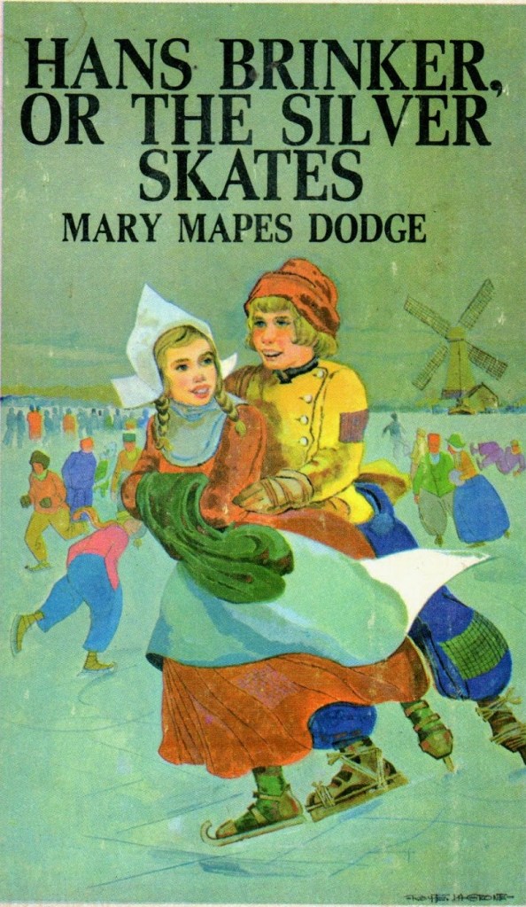
It was a Yankee, Mary Mapes Dodge, who wrote Hans Brinker, or The Silver Skates: A Story of Life in Holland. The book was published in New York in 1865. It tells the story of Hans, a poor fifteen-year-old boy, and his sister, Gretel. Gretel wins the Silver Skates, the prize awarded to the winner of an ice-skating race. After she won, everything turns out for the best, and the Brinkers are one happy family. The book also contains the story of the Hero of Haarlem: the world-famous tale of a boy who sticks his finger into a leaking dyke and prevents a disaster. But did he really? More importantly, is building ever-higher dykes the best long-term strategy for dealing with rising sea levels, or should we rethink the way we protect ourselves from the sea?
The Hero of Haarlem was an eight-year-old boy who, one day, was asked to deliver a cake to an old, blind man. Our future hero was a kind and thoughtful little boy. But he lost track of time. When he finally rushed home that evening, something unexpected caught his attention:
“Just as he was bracing himself for a run, he was startled by the sound of trickling water. Whence did it come? He looked up and saw a small hole in the dyke through which a tiny stream was flowing. Any child in Holland will shudder at the thought of a leak in the dyke! The boy understood the danger at a glance. That little hole, if the water were allowed to trickle through, would soon be a large one, and a terrible inundation would be the result.
Quick as a flash, he saw his duty. Throwing away his flowers, the boy clambered up the heights until he reached the hole. His chubby little finger was thrust in, almost before he knew it. The flowing was stopped! Ah! he thought, with a chuckle of boyish delight, the angry waters must stay back now! Haarlem shall not be drowned while I am here!”
It was at daybreak, after a very chilly autumn night, when he was finally discovered by a clergyman. Of course, this symbolized the aid of God. Still, the kid had his finger in the dyke solidly. This is how the dutiful boy saved the town of Haarlem and how he became a hero.
INTERMEZZO
Haarlem — The name Haarlem appears for the first time between AD 918 and 948, referring to the settlement of Haralem in Frisia. Today, Haarlem is the capital of the province of Noord-Holland. The name is thought to be a combination of haar or harula, meaning ‘sand ridge’ or ‘little sand ridge’, respectively, and heem, meaning ‘homestead’. Thus, Haarlem can be interpreted as ‘homestead on a little sand ridge’ (Van Berkel & Samplonius 2018).
With the foundation of New Amsterdam by the Dutch in the colony of New Netherland, which later became New York City, the neighbourhood of Harlem was given its name. See our blog post History Is Written by the Victors — A Story of the Credits to learn more about New Amsterdam, the colony of New Netherland, and the role Frisians played in its creation.
Of course, the entire story of the Hero of Haarlem is fictional. Hans, or Hansje Brinker, and the Hero of Haarlem are often confused with one another by the public and in other accounts. However, they are two distinct characters in Mary Mapes Dodge’s book (Jensen 2021).
Hero Arie Evegroen
There is, however, a real hero in the Netherlands who helped prevent a dyke, also known as a levee, from being breached. His name was Arie Evegroen (1905–1988). He did not stick one of his fingers into the dyke. No — it was something much bigger! It happened during the storm surge Watersnoodramp (literally, ‘water emergency disaster’) of 1953, known as North Sea flood in English.
On the infamous night of Saturday, 31 January, dykes breached across the province of Zeeland, claiming 2,551 lives. A similar disaster threatened the province of Zuid Holland. But for Arie Evegroen, the outcome might have been very different.
It was Saturday evening. The storm had breached the Groenendijk (‘green dyke’) near the village of Nieuwerkerk aan den IJssel, and water was already pouring through the breach. A few fingers would not do the trick this time.
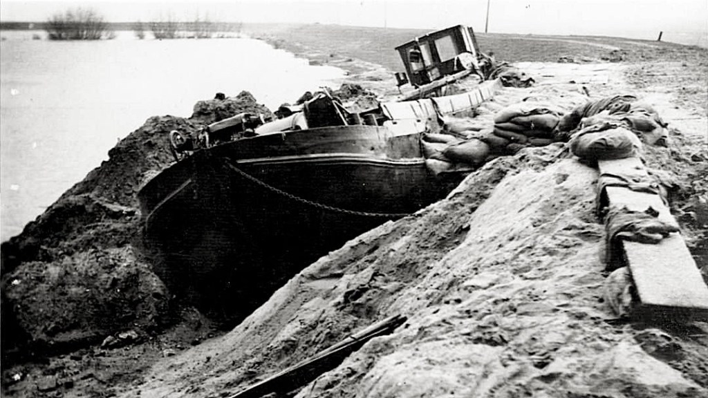
Arie and several other men were sitting in the local pub, apparently still relaxed and sipping jenever, when the mayor walked in. He told them he needed a ship to plug the hole in the dyke. The mayor persuaded Arie to take his 18-metre-long grain barge, named Twee Gebroeders (‘two brothers’), and navigate it into the breach.
Arie succeeded. Quick as a flash, he skilfully manoeuvred his ship into position and plugged the breach. After that the Groenendijk hold. By doing so, he prevented most of the province of Zuid Holland — including the cities of Rotterdam, Leiden, and The Hague — from being flooded that tragic night. An area inhabited by around three million people was spared.
Arie Evegroen became known as the Redder van Zuid-Holland (‘saviour of Zuid Holland’) We think that must have deserved an extra round of jenever in the pub. And, on top of everything else, he clearly had some great parking skills!
Building Dykes: An Arms Race
Hans Brinker and the Hero of Haarlem are the kind of stories that reinforce an almost supernatural belief that, by continually building stronger, thicker, and higher dykes, we can keep the dangerous sea at bay forever — that we can control nature.
Sayings such as wer nicht will deichen, der muss weichen in German, or wie niet wil dijken, moet wijken in Dutch, are chauvinistic regional classics. Both mean roughly, ‘whoever does not want to build dykes must give way’. Similarly, in the Low Saxon language of the province of Groningen, there is the saying Gain diek. Gain laand. Gain leev’n, which translates as ‘no dyke, no land, no life’.
These sayings reflect a deeply rooted belief that our survival depends on continuously defending ourselves against the sea. Yet the enormous bulwarks that have been constructed along the southern North Sea coast — from the region of West Flanders in Belgium in the west, all the way to the southwestern tip of the region of Jutland in Denmark — may become our enemy in the long run.
Dykes have a long history. Dykes were already being built around the beginning of our era on the salt marshes along the Wadden Sea. In fact, the very name Frisian is derived from their earth cutting labour. See our blog post A Severe Case of Inattentional Blindness — The Frisian Tribe’s Name to learn more on this.
The earliest dykes were low summer dykes, built to protect the salt marshes from the sea during the growing season and to regulate the flow of water across the land. They did not, however, attempt to shut the sea out completely. During spring tides and storms, seawater could still flow freely across the vast tidal marshlands. People adapted to this dynamic landscape by living on terps (‘artificial dwelling mounds’), which provided dry ground when the surrounding land was flooded. This relationship with the sea began to change towards the end of the first millennium. People increasingly raised higher dykes. This evolved into systems of dykes and sluices that kept the sea out altogether.
From around the eleventh century AD onward, this coincided with large-scale commercial peat excavation along the southern North Sea coast. Go to our blog post The United Frisian Emirates and Black Peat. How Holland Became Dutch to read about the history of this ‘brown gold’. Behind and underneath the salt marshes lay vast peatlands, stretching all along what would eventually become the route of the Frisia Coast Trail.
Besides contributing to global warming as early as the High Middle Ages by unlocking vast amounts of stored carbon, commercial peat cutting also resulted in massive losses of land during major floods. Sometimes, entire islands and towns disappeared beneath the waves in a single night. Check out our blog post How a Town Drowned Overnight. The Case of Rungholt to learn more about one of the most spectacular examples.
The raising of the dykes continued, especially after the storm floods of 1953 and 1962, which devastated parts of the Dutch and German coasts respectively. At present (2025), in the Netherlands these snake-like monsters rise to a staggering 12 metres above Ordnance Datum (MoD) — and they are still growing. In Germany, the dykes are generally a bit lower. A true boa constrictor.
Constructing high dykes was not something unique to the sea coast. For many centuries, this arms race also took place in the central river lands along the lower reaches of the mighty rivers Meuse and Rhine. Here, every community and village had to build its own dykes. If yours were higher and stronger than those of your neighbour, your neighbour was at a disadvantage. Not you (Rooijendijk 2009). Dutch tolerance, explained in a nutshell. But let us put that aside for now.
It was the people of Sliedrecht, a small town on the Beneden-Merwede, a branch of the Lower Rhine, who became the ultimate river-dyke constructors in world history. For this Darwinian achievement, their descendants were rewarded with some of the world’s leading dredging companies — which made them filthy rich, too.
Their skills proved indispensable when constructing the 30-kilometre-long Afsluitdijk (‘enclosure dam’) almost a century ago. But Sliedrecht’s dredging companies have also been reshaping coastlines far beyond the Netherlands, including that of the United Arab Emirates, to give just one example. Deus mare, Sliedrechti litora fecit.
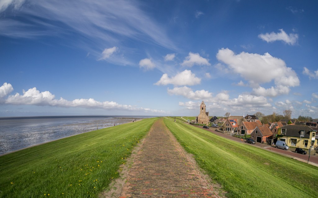
But the dyke-building race came at a price. Sealing off the land from the influence of the sea meant, first and foremost, that the land behind the dykes could no longer receive fresh layers of silt. It gradually dried out, subsided, and shrank. Indeed, it turned into the very opposite of the landscape described in Mapes Dodge’s book about Hans Brinker and the Hero of Haarlem. We might just as well call it bathtub country without a drain.
Furthermore, before the high dykes existed, the waterwolf could spread out over vast areas of tidal marshland during storm floods. The terpen on which people lived were, on average, no more than about 4 metres above Ordnance Datum (OD). Higher was simply not necessary. During storms, the sea could flow freely across the enormous salt-marsh areas, generally without causing too much damage, thanks to their immense capacity to store water.
The highest terp of all is the one at the hamlet of Hogebeintum in the province of Friesland, in the Netherlands, rising to almost 9 MoD. Why the people of Hogebeintum built such a high terp in the Middle Ages, when a height of 4 MoD was already sufficient, remains a mystery. Was it perhaps to show off? “Look at us, we have a big terp!” Or did they simply have too much spare time on their hands?
Anyway, if you want to learn more about terps, from the west of the region of Flanders in Belgium to the south-western tip of Denmark, see our blog post Between Leffinge and Misthusum — Understanding the Basics of Terps.
Low summer dykes surrounding the terp on the tidal marshlands also functioned as small barriers, helping to dampen the waves during storms. Once the heavy dykes had been built, however, the North Sea was — and still is — pushed up against the coast by onshore winds. During storm floods, this can result in water levels that are, on average, 1.5 metres higher than they were before the construction of the high dykes.
As a result, the safety situation became considerably more dangerous if these dykes failed. Perhaps this is one reason why, from around the eleventh century AD onward, when large-scale dyke building got underway, the number of deaths along the southern North Sea coast appears to have increased sharply. See our blog post Half a Million Deaths. A Forgotten North Sea Disaster….
They thought they were safer behind the wall. In reality, they may have made themselves more vulnerable.
INTERMEZZO
Terps, a Current Solution — The need to give more space to the rivers has been recognised in the central river lands of the Netherlands in recent decades. Here, the major rivers are now given room to spread out during periods of high water. In the Overdiepse Polder in the province of Noord Brabant, no fewer than eight new terps have even been constructed as part of these new Delta Works. If you want to know how to build a terp, check out the first — and only — DIY manual: Making a Terp in Only 12 Steps.
Sea Is Such a Diva
Now the Earth is confronted with rapidly rising sea levels as a result of global warming. Although archaeology and geography have largely abandoned the theory that sea-level transgression caused the deterioration of the coastal zone of the southern North Sea, including periods of depopulation (Van Steensel & Chamuleau 2021), there is still reason for great concern.
Within Europe, the area crossed by the Frisia Coast Trail has been identified as one of the areas most vulnerable to the effects of global warming. Can people continue to live along the seashore in the long run? Most importantly, can we still hike the Frisia Coast Trail in the future? Should the dykes be reinforced and made even higher, broader, stronger, and fatter?
Or is it time to rethink our relationship with the sea?
More and more people, including scientists, are calling for an end to — or at least a rethinking of — this arms race, leaving behind the ancient reflex: wer nicht will deichen, der muss weichen (‘those who refuse to build dykes must make way’).
Their plea is to restore the dynamics of the sea as much as possible. Give the sea, just as we have done with rivers, more space again. This would allow land to silt up once more and reduce the risks of dykes leaking or breaking. No more Heroes of Haarlem or Arie Evegroens needed.
And as an added bonus, it would create a far more spectacular and diverse natural landscape.
Not controlling the sea, but managing it. Making a compromise. Working with the waterwolf, rather than fighting it. That way, as sea levels rise, the land can rise with them. It was done for many centuries before high dykes existed. So why not do it again?
This new strategy reminds us of a quote from the former Iraqi Minister of Information:
We are going to cut this snake in two!
Mohammed Saïd al-Sahaf (2003)
The inhabitants of the village of Holwerd in the northeast of the province of Friesland even developed advanced plans to open the dyke and give the sea more space again. The project had strong local support, and truly substantial amounts of money had been raised to make it happen.
But in 2024, after more than a decade of preparation, the original Holwerd aan Zee project was abandoned. There was no agreement on who would take long-term responsibility for the ownership, management, and maintenance. Neither the regional authorities nor the regional water board Wetterskip Fryslân was willing to take on that responsibility. So, despite the enthusiasm of the people of Holwerd and millions of euros having been raised, the plan to reconnect the village with the Wadden Sea came to a halt.
Apparently, giving the sea truly more space is still one step too far for the regional government bodies.
Nearby, at the village of Blije, another grassroots initiative exists — grassroots, of course, in the Puccinellia sense. Here, the local community has built a new terp on the other side of the dyke, out on the salt marshes. This art project is called Terp fan de Takomst (‘terp of the future’). It was completed in 2022 and officially opened on 16 July that year. The advantage of this project was that there was no need ‘to cut the snake in half’.
Giving the sea — more specifically, the Wadden Sea — access to the land is also being experimented with near the village of Bierum in the east of the province of Groningen. Here, openings have been made in the dyke using tubes, creating what is known as a permeable dyke. The idea is to allow sediment-rich seawater to enter the land again, so that it can gradually ‘grow’ upwards (Schuttenhelm 2023). Apparently, the people of Groningen are a little braver than their western neighbours.
Similar developments have taken place at National Park ‘t Zwin in the northwest of the region of Flanders, which is also the starting point of the Frisia Coast Trail. In 2019, the Internationale Dijk (‘international dyke’) was opened up to make way for the sea.
Another example is the massive Haringvliet storm-surge barrier in the Netherlands, whose sluices have recently been left slightly open to give salt water and migrating fish continuous access. A less rigid separation between salt and fresh water, intended to stimulate biodiversity.
And then there is the Afsluitdijk (‘enclosure dam’), where the construction of the Vismigratierivier (‘fish migration river’) is now entering its final phase. After years of preparation, construction began in 2019, and the final part of the artificial river is now (2026) being built on the Lake IJsselmeer side of the dyke. Once completed, the Vismigratierivier will reconnect the Wadden Sea and the Lake IJsselmeer, allowing migratory fish to move freely between salt and fresh water again. Although the 30-kilometre-long Afsluitdijk is also being reinforced and heightened. Yes, still fattening the boa constrictor.
Lastly, universities such as Wageningen University in the Netherlands are experimenting with salt-tolerant agriculture. The aim is to prepare for the future, as the process of (re)salinisation is already taking place in coastal areas. Wageningen University has also identified a range of adaptation pathways for the Frisian coast, exploring how the region could cope with rising sea levels in the long run. Interestingly, some of these pathways draw inspiration from solutions that were already used in ancient Frisia.
Although everything is still very much on a small scale, this incomplete overview of initiatives may be the first signs of a new way of thinking. The idea that total control — and a world that can be completely engineered — is not the only solution, and perhaps not even a viable one in the long run. The world and nature are simply too complex. Do not put all your eggs in one basket, as the saying goes.
Focusing on the sea and its coastline, the consequences are clear: people may need to learn to accept the sea — and its salt — again. With rising sea levels, there is an increasing need for additional space to store seawater during storm surges and other periods of high water. This could be combined with the need to halt the subsidence of the land behind the dykes and, where possible, allow it to silt up and rise again. Such an approach could make the coastline more resilient and reliable in terms of safety. At the same time, it would greatly enrich nature. As the Frisians of the region of Nordfriesland say today when their Hallig islands (see further below) are flooded: ‘After every storm, the island has grown.’
Precisely because of the need for the land to gradually rise along with the rising sea, we were surprised to see that the recent debate has focused on raising the water level of the Lake IJsselmeer. This is considered necessary because of the expected increase in droughts, also as a result of climate change (De Stentor 2026). Why nobody seems to be considering the alternative of deepening the Lake IJsselmeer and using the fertile former sea clay to help the land along the coast grow with the rising sea — and thereby potentially avoiding the enormous costs of adapting dykes, harbours, and other infrastructure — is completely beyond us.
Anyway, people will have to adapt. We must learn to behave more symbiotically and less parasitically towards our environment.
Perhaps there is an additional benefit to be gained along the way. If the area of wetlands along coastlines around the world were expanded, more carbon could be captured and stored again, since wetlands are particularly effective carbon sinks. In doing so, they could also help slow global warming. There are already many initiatives around the world aimed at conserving and restoring wetlands, including the Convention on Wetlands.
For those readers who think it is no longer possible to live without high dykes, there is a remarkable example just south of the Danish border, along the German Wadden Sea coast. Here, people still live in the full dynamics of the sea. To this day, they are regularly surrounded by water during high floods — a phenomenon they call Landunter.
We are talking about the Nordfriesen (‘North Frisians’) and their islands and Halligen in the region of Nordfriesland. Their terps, locally known as Warften, are currently being raised, but their summer dykes are not. Instead, these Frisians still allow their islands to silt up and rise with the sea level, just as people have done in this region for more than 2,000 years.
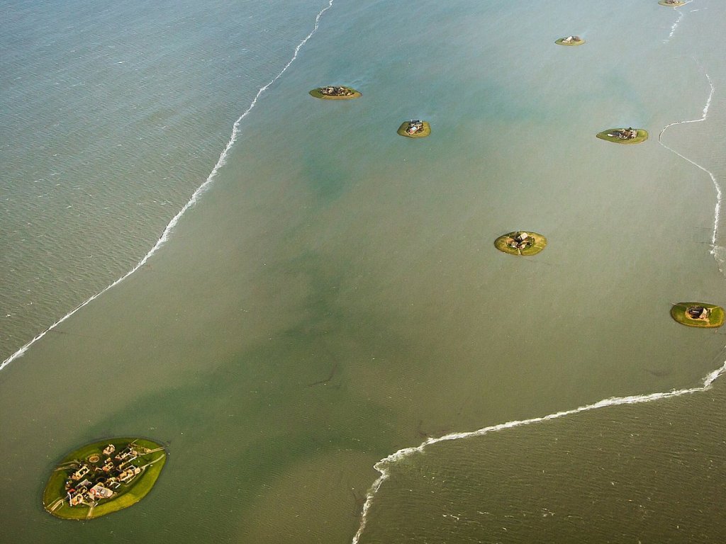
With all this in mind, we can take inspiration from grassroots initiatives along the southern North Sea coast. After communities closed themselves off from the sea in the Middle Ages and gradually transformed from a seafaring people into a classic agricultural people, they are now slowly turning towards the eternal sea again — and seem to be embracing it.
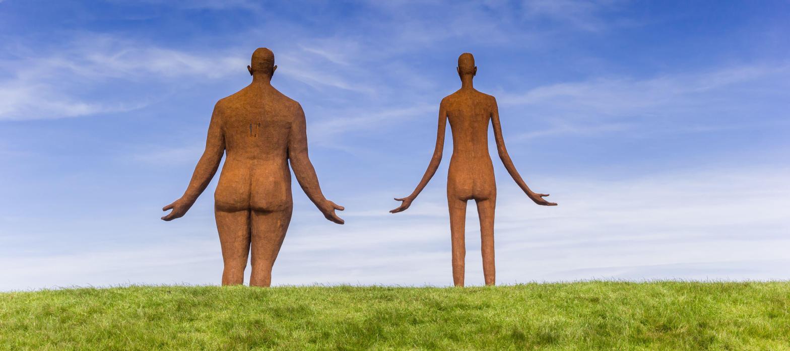
This is almost literally visualised by the huge sculpture by artist Jan Ketelaar, standing on top of the bulwark dyke at the village of Holwerd in the province of Friesland. A naked woman and man stand with their arms spread wide, their feet firmly planted in the clay of the dyke, waiting for the flood to come (see the featured image of this blog post).
Let’s understand from now on that the Hero of Haarlem is actually a dragon in disguise. Let’s take those fingers out of the dykes. Let’s make the wetlands of the southern North Sea coast flourish again!
Or, inspired by the words of a certain former American president:
“TEAR DOWN THIS DYKE!”
Note 1 — We work on a back-up plan as well, namely that the sea level rise will be mitigated by exporting the additional water to desert areas on the planet. Salty wetlands in Chad, Egypt, and Algeria. Yes, it is possible!
Note 2 — Mary Elizabeth Mapes Dodge (1831-1905) was born in New York City. She had a rough time when her husband left her behind with her two young children, and was found dead soon after. Although from a well-off family, Mary started to work as publisher and became a writer. Inspired by John Lothrop Motley’s ‘Rise of the Dutch Republic’ and ‘History of the United Netherlands’, she wrote ‘Hans Brinker, or the Silver Skates’. It was published in 1865, and immediately was a bestseller.
Note 3 — Featured image ‘waiting for high tide’ by Ketelaar (sculpture), by Venema (image).
Suggested music
- The Doors, Break On Through (To The Other Side) (1967)
- Julian Lennon, Saltwater (1991)
Further reading
- Berkel, van G. & Samplonius, K., Nederlandse plaatsnamen verklaard. Reeks Nederlandse plaatsnamen deel 12 (2018)
- De Stentor, IJsselmeer moet tientallen centimeters hoger tegen droogte, maar dat raakt havens, natuur én mogelijk steden (2026)
- Jensen, L., Hoe de strijd tegen het water de Nederlandse identiteit vormde (2021)
- Klerk, de A., Vlaardingen in de wording van het graafschap Holland 800-1250 (2018)
- Knottnerus, O.S., Sea level rise as a threat to cultural heritage (2003)
- Liefde voor Holland, Verhaal Hans Brinker berust op waarheid (2016)
- Middendorp, H., Zuid-Holland ontsnapte ternauwernood aan Watersnood in 1953 (2018)
- Nieuwhof, A., Bakker, M., Knol, E., Langen, de G.J., Nicolay, J.A.W., Postma, D., Scheper, M., Varwijk, T.W., Vos, P.C., Adapting to the sea: Human habitation in the coastal area of the northern Netherlands before medieval dike building (2019)
- Oosthuizen, S., The Anglo-Saxon Fenland (2017)
- Rooijendijk, C., Waterwolven. Een geschiedenis van stormvloeden, dijkenbouwers en droogmakers (2009)
- Ruyter, de P., Vloeiend landschap. Over de toekomst van het Friese landschap (2016)
- Schroor, M., Strategies for future flood protection in the Wadden coastal area: Exploring adaptation measures with cultural-historical elements in Fryslân (2019)
- Schuttenhelm, R., Dijk met gaten moet Groningen mee laten groeien met de zeespiegelstijging (2023)
- Steensel, van A. & Chamuleau, B., Water, land en dijken. Het ontstaan van middeleeuws Noord-Beveland (2021)
- Teetied & Rosinenbrot (podcast), Die Weihnachtsflut 1717 — wer schützt heute die Deiche? (2021)
- Vogelbescherming Nederland, Project Holwerd aan Zee stopt (2024)

