21 August 1930, Wieringermeer in the province of Noord Holland. The reclamation of just another piece of the Zuiderzee ‘southern sea’ was completed. A wooded area, when it was still land, that was called Creilerwoud. Land lost to the sea eight centuries ago during the most destructive All Saints’ Flood in the year 1170. The embanked land — or polder in the Dutch language — is now being named Wieringermeerpolder instead of Creilerwoud. A few years after the reclamation, settlers from all corners of the Netherlands moved to the new fertile land. But it was not for long that these pioneers would keep their feet dry.
The first three villages established in the Wieringermeerpolder were Sluis I, Middenmeer, and Wieringerwerf. Their original names were functional and rather matter-of-fact.
Sluis means ‘sluice,’ referring to the water-management infrastructure central to the reclaimed polder landscape. The village of Sluis I was later more elegantly rebranded as Slootdorp, meaning ‘ditch village.’ A real improvement… Middenmeer translates as ‘middle of the lake,’ reflecting its position within what was once a body of water — quite literally a settlement in the centre of a former lakebed. Wieringerwerf means ‘werf of Wieringen,’ with werf referring to an artificial dwelling mound or terp. This term is cognate with forms such as warf, wurt, or værft in northern Germany and southern Denmark, and with werve as used in parts of southwestern the Netherlands, particularly Zeeland.
INTERMEZZO
The Wier of Wieringen — Wieringen as such is a former island at the convergence of the (former) Zuiderzee ‘southern sea’ and the Wadden Sea. Its early-medieval names were UUiron, Wironi, and Wirensi. All originating from the Old Frisian word wîr or wier meaning ‘raised mound’ (Van Berkel & Samplonius 2018). Therefore, the name Wieringerwerf is a tautology, namely the Wier of Wieringen.
See our blog post Between Leffinge and Misthusum — Understanding the Basics of Terps to get a better picture of what these werf, warf, werve, wurt, etc. earthworks are.
In addition, there are indications that Vikings have settled on the island of Wieringen. Especially, two silver hoards found on Wieringen point towards this.
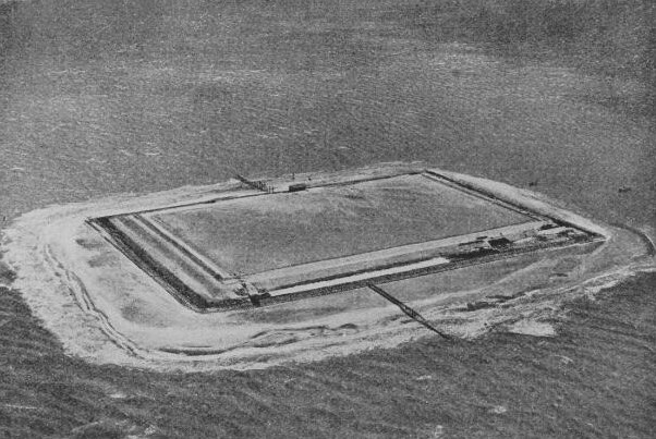
Indeed, when the Wieringermeerpolder and the settlement of Wieringerwerf were established in 1930, a new terp was constructed as well. It was, so to speak, a ‘just-in-case’ terp, even though the polder was already protected by a high surrounding dyke. This was an impressive, square-shaped structure of about four hectares, complete with a high-quality freshwater well. It is likely the largest terp ever built.
By 1930, this earthwork marked the latest chapter in a long tradition of landscape engineering that began around 600 BC in the salt marshes of the Wadden Sea, in what is now the Netherlands and Germany. Seen in that light, it can be understood as a terp of such scale and refinement that the Iron Age Frisian terp dwellers of the Iron Age might well have admired — perhaps even envied — it. Had they laid eyes on it, they would have been licking their fingers.
Moreover, the engineers behind this ‘just-in-case’ terp 2.0 showed remarkable foresight, as will become clear further on.
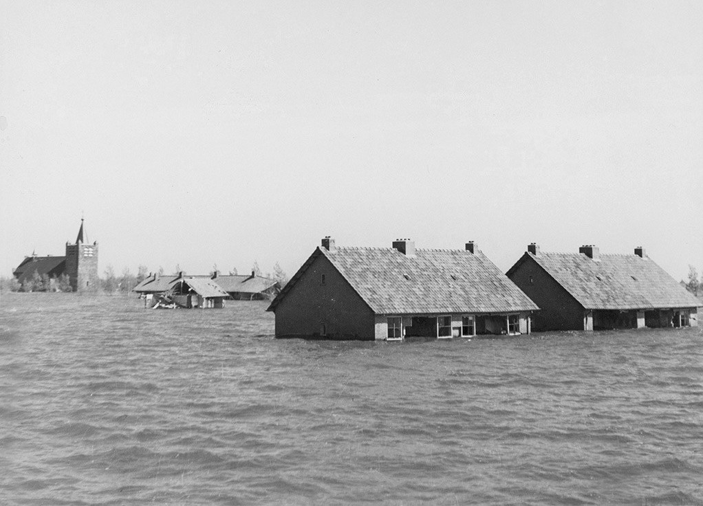
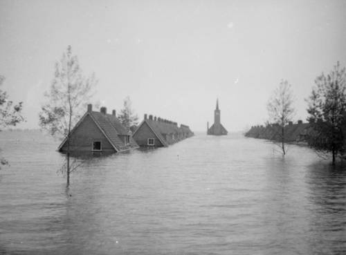
On 17 April 1945, at 12:00 o’clock sharp, a desperate and frustrated Nazi army, out of anger and in an effort to delay the advance of the Allies, blew up the dyke protecting the young Wieringermeerpolder. Most of the 7,000 pioneers of Wieringermeerpolder fled with their bikes, horses, carriages, carts, cattle, etc., away from Wieringermeerpolder, whilst the water was rising steadily to a level between 0.5 and 5 meters above the 15-year-old land.
When the inhabitants of the polder reached the surrounding higher grounds and dykes, part of them were awaited by soldiers. Some were taken prisoner, and one leader of the Resistance was shot on the spot.
INTERMEZZO
Beemsterpolder — On 21 February 1945, the Nazi army had ordered also the inundation of the Beemsterpolder already, south of the Wieringermeerpolder in the province of Noord Holland. At the end of May 1945, the polder had been drained again.
But not all fled.
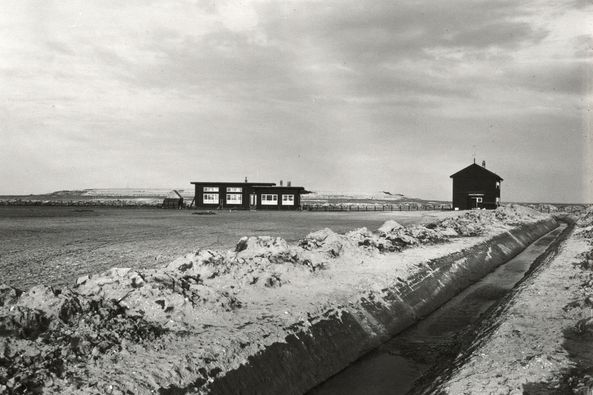
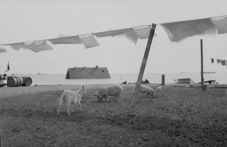
Three families from the village of Wieringerwerf — twenty-three people in total — made their way to the ‘just-in-case’ terp that day. Among them were several children who had fled the city months earlier during the so-called Hongerwinter (‘hunger winter’) famine of 1944–1945. They are often described as coming from Amsterdam; however, a witness and temporary resident of the terp, Lammy Stolp, says that the children were in fact from Rotterdam (see image below). Rotterdam, the city that was levelled by bombing in May 1940.
The twenty-three refugees walked up the terp, hoping the rising water would not go beyond the highest level of the terp. If it did, they would be trapped. But it did not. The water engineers had done a proper job fifteen years back. On the terp, everyone was protected, not only from the rising water but also from the raging Nazis and the chaotic final chords of the Second World War.
Besides people, animals also reached the terp for safety. There were six cows, a few pigs, a goat, a sheep, and some rabbits, as well as a cat and a dog. The owners of the sheep and the goat were unknown. In addition, several clever — or lucky — uninvited hares stayed on the terp as well. The cows provided the people with milk. Some people lived in a tent, while others were on boats docked on the terp’s slope. No moles have been sighted, so they might have had a hard time surviving the inundation of the polder.

Only three days after they had occupied the terp, the first of three storms struck the area. In a sense, these were almost welcome, as they brought driftwood ashore — material the new terp dwellers could use to build a shelter. In that respect, their situation echoed that of terp dwellers centuries earlier, when wood was just as scarce on the salt marshes along the Wadden Sea coast.
But after two more storms it was enough. The group left this safe haven on 7 May 1945, heading for the drier grounds of a country that had been liberated from its occupier in the meantime.
On 11 December 1945, the Wieringermeerpolder was fully dry again, and life could resume its pace. From then on, all inhabitants could return to their properties. In the meantime, the polder had been sealed off to prevent looting, and visiting one’s property was only possible with permission. Only the people of the village with the beautiful name Slootdorp could return earlier, in the month November (Historisch Genootschap Wieringermeer 2025). Today, the polder has around 13,000 inhabitants.
For the folks living on the Hallig islands in the region of Nordfriesland in northern Germany bordering Denmark, the unique sight of people living on a terp surrounded by water, a phenomenon locally called Landunter, is still the daily norm. For the Dutch, it is no longer so. But once again, the whole tragedy of 1945 proved that after 2,600 years of terp culture, those raised settlement mounds are still a current and very solid solution in modern water management. Excellent also for a society being ‘resilient’ — popular language by politicians and policymakers these days (2026).


The site where the dyke of the Wieringermeerpolder was blown up by the Nazi army, on the eastern edge of the polder, is still clearly visible — a scar, if you like, though a striking one. Here the dyke curves outward in a gentle semicircle into the IJsselmeer. On the landward side of this bend lie two kolken — known in Dutch as wielen (‘wheels’) and in German as Brack or Brake. These small lakes were formed by the force of swirling water rushing in when the dyke was breached. The surrounding area is densely wooded, in marked contrast to the open landscape that characterizes most of the polder.
Within this forest, at the time of writing, there is a nature camp site called Het Bos Roept ‘the woods call.’ It is filled with Millennials and their long-haired, mostly blond children from Amsterdam. Not the type of children who fled the Hongerwinter, as described earlier.
Also, in the month of September, at this scar-location near the Dijkhuis, is a modest but very charming music festival called Gat in de Dijk, which quite aptly translate as ‘hole in the dyke’. So, more reasons worth making a detour and staying the night there while hiking the Frisia Coast Trail.
Note 1 — If the reader is just as excited about terps as we are and cannot wait to construct his own settlement mound, find here the first and only DIY manual Making a Terp in Only 12 Steps. Take care and do read the warnings carefully!
Note 2 — Hiking the Frisia Coast Trail one will pass the young terp of Wieringerwerf. The fresh water well has been replaced by a swimming pool, though. At the time of writing (2018), the swimming pool was slightly in disrepair. In 2023-2024, the terp underwent a total remake and is now known as Campus de Terp with all kinds of leisure activities.
Note 3 — If the reader understands the Dutch language, there is also a very informative documentary of the Wieringermeer catastrophe of 1945, click here.
Note 4 — For another story about the end of the Second World War along the Frisia Coast Trail, go to our blog post Der Friesenwall. An Unfinished Last-Ditch Coastal Defence System.
Suggested music
- Radiohead, High and Dry (1995)
Further reading
- Berkel, van G. & Samplonius, K., Nederlandse plaatsnamen verklaard. Reeks Nederlandse plaatsnamen deel 12 (2018)
- Guðmundsdóttir, L., Wood procurement in Norse Greenland (11th to 15th c. AD) (2021)
- Netherlands Water Partnership, Restored to full glory: dwelling mounds for flood protection (2015)
- Oneindig Noord-Holland, De meidagen van 1940 (2012)
- Regionaal Archief Alkmaar (website)
- Rooijendijk, C., Waterwolven. Een geschiedenis van stormvloeden, dijkenbouwers en droogmakers (2009)
- Vries, de F., Wieringermeer: Drie miljoen dakpannen gered uit het water: berging cruciaal voor wederopbouw (2025)
- Zijper Museum (website)
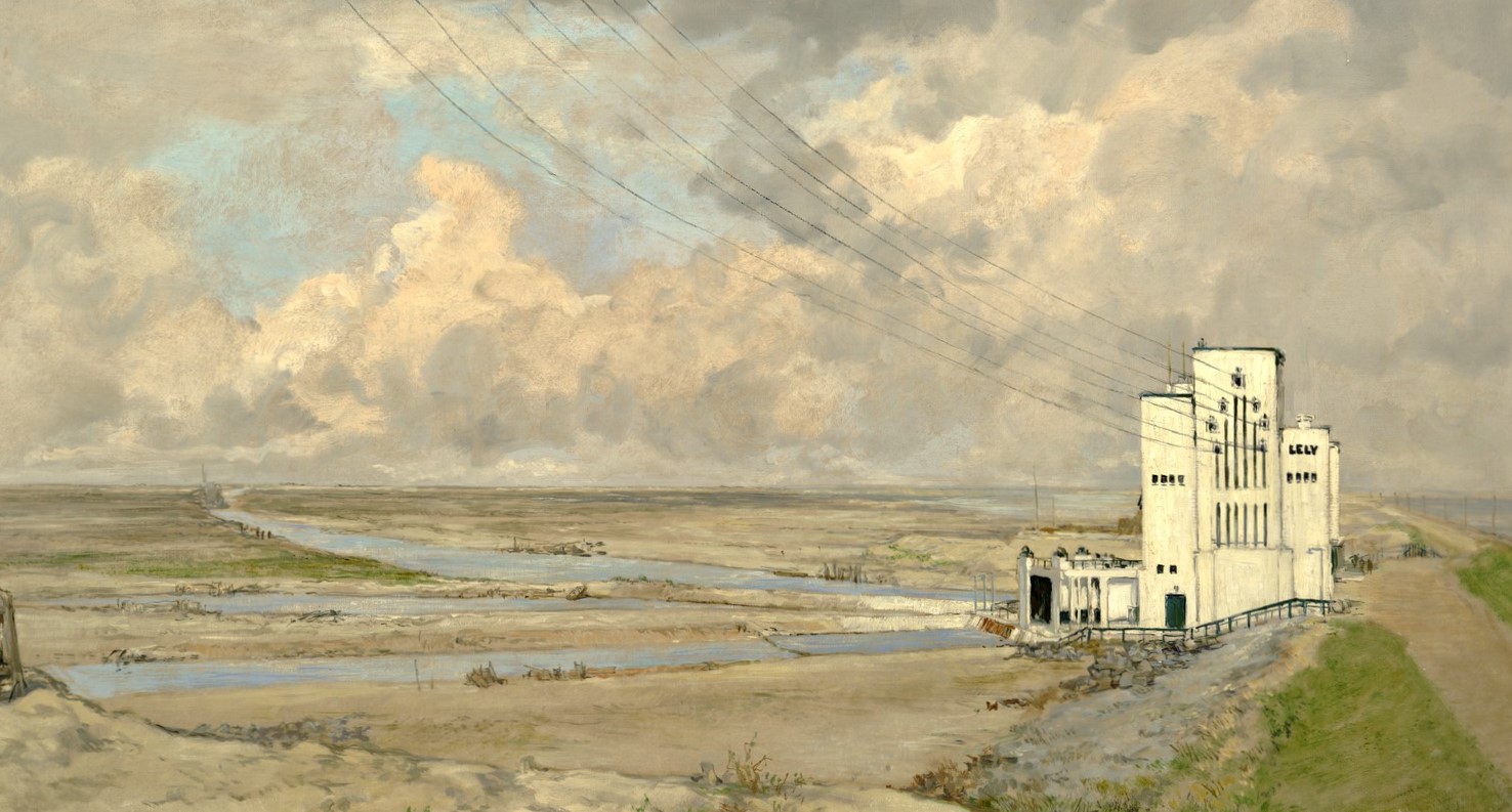
credit featured image: pumping station Lely by Joh. H. van Mastenbroek
