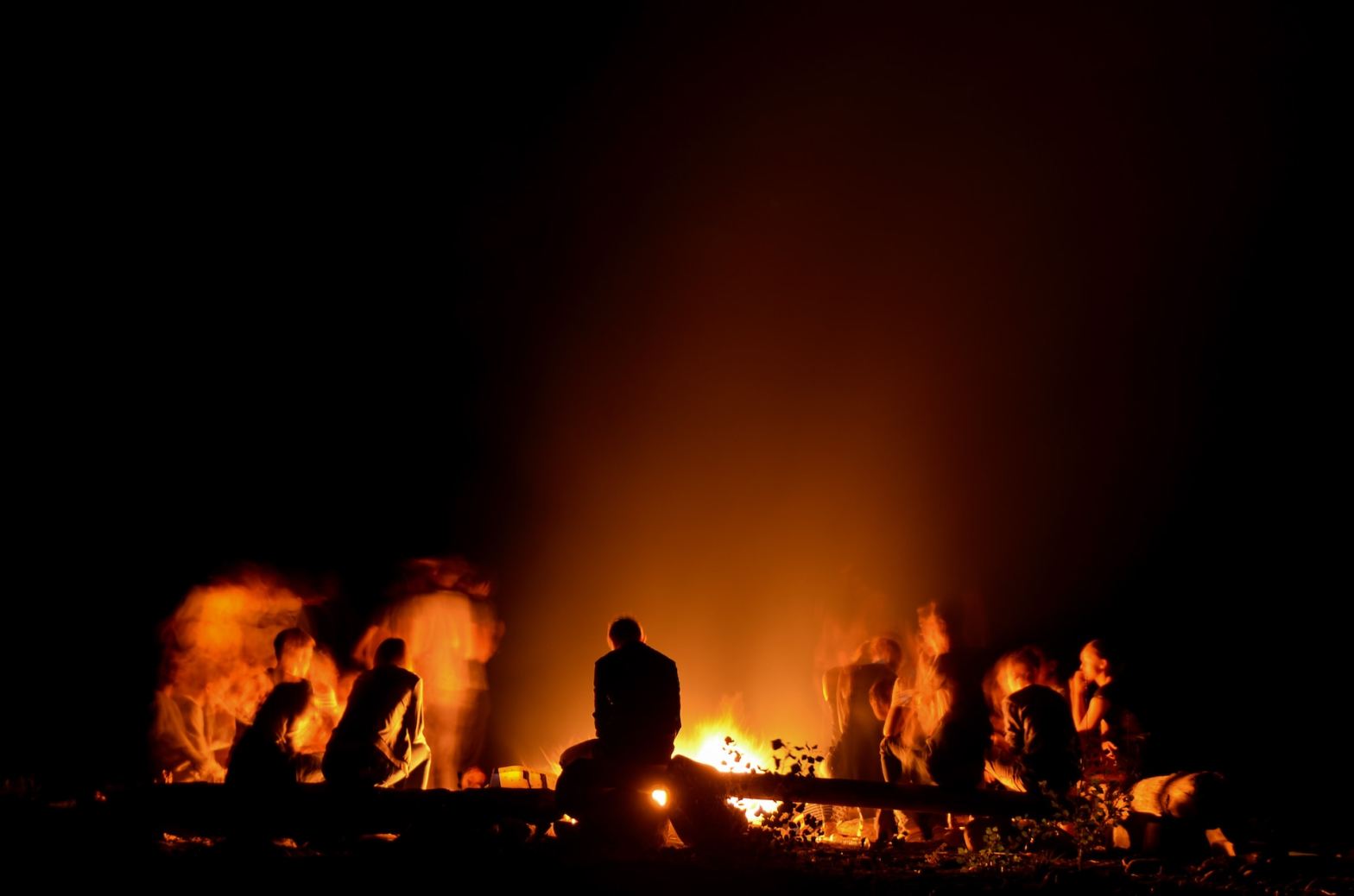
Nordfriesland, or North Frisia, forms the western coastal and island zone of the cultural region of Schleswig. Extending from the Danish town of Tønder in the north to the River Eider in the south, it consists of a broad maritime strip together with fifteen offshore islands and Halligen, or Hallig islands. It is here that a distinctive bonfire celebration takes place every year on 21 February. Much speculation surrounds the (pagan) origins of these large communal fires and the reasons why the people of Nordfriesland began lighting them. The celebration is known as Biikebrånen or Biikin in the North Frisian language, and as Biikebrennen or Biike in the Low Saxon language. In this blog post, we will use, somewhat arbitrarily, the term Biikin, the form found in the Fering variety of the North Frisian language spoken on the Wadden Sea island of Föhr.
All the different names of the celebration immediately touch upon one of the difficulties one encounters when writing about Nordfriesland, namely its language and the many dialects, which differ enormously. In some cases, there are even several sub-dialects on a single island. This diversity already becomes clear in the name Nordfriesland itself. Depending on which North Frisian sub-dialect is used, the region is called Nordfraschlönj, Noordfreeskluin, Nuurdfriislön, Nuurdfresklun, Nuardfresklun, nordfriislun, or Nöördfreesklöön.
This fragmentation into many strongly differing sub-dialects, spoken today by only a few thousand active North Frisian speakers, presents a serious challenge to the survival of the language. Indeed, the outlook for North Frisian is grim. The language is already extinct in the southern part of Landkreis ‘district’ Nordfriesland, between the town of Husum and the River Eider. If the reader is interested in this topic, please consult our page Language.
Back to the topic of this blog post: fire fire!
Biikin celebrations take place on the North Frisian Wadden Sea islands, the Hallig islands, and on the peninsula of Eiderstedt. They also occur on the Wadden Sea islands of southern Denmark. It is less common on the mainland of the region of Nordfriesland, but Biikin celebrations are gaining popularity there, too.
Big stacks of wood are placed on beaches or elsewhere along the endless shores of Nordfriesland. The stacks are lit on the night of 21-22 February. 22 February is the feast day of Saint Peter, patron of fishermen and sailors, among others. Traditionally, the Catholic feast day of Saint Peter marks the start of the sailing season for Frisian skippers and sailors. A tradition dating back to the Middle Ages. The sailing season ended on the feast day of Saint Nicholas in the first week of December.
Different ritual of Biikin exist, but the burning of straw puppets named Petermännchen (‘little Peter men’) is quite often practiced. According to some, the straw puppet or der Mann actually symbolizes the Pope in the city of Rome. Whatever it represents, this clearly also explains the origin of the annual event of Burning Man, which takes place in the month August or September in the hot desert of the State of Nevada in the United States.
INTERMEZZO
(pagan) Rituals – None other than Julius Caesar wrote in the first century about the Germanic ritual to make huge images called Simulacra. These big dolls or, indeed, giant Petermännchen, made of willow were stuffed with living humans. After that, the giant doll was lit and the humans inside burned alive.
In the village of Grou in the province of Friesland, and before also in the village of Gees in the province of Drenthe, the tradition of Sint Piter exists. The name day of Sint Piter is on 22 February. Today, Sint Piter arrives at Grou a few days earlier, but originally he arrived on 21 February, together with his help Hantsje Pik. He used to wear a long coat on which candy was attached. In the evening, Sint Piter would go from door to door and ask if there were any naughty children to put into the sack to take with him. If not, children could take some candy from his coat. These days, Sint Piter’s appearance is very similar to that of Sinterklaas (Saint Nicholas), which is a tradition in the Netherlands celebrated in the evening of 5 December. The progenitor of Santa Claus.
Still, the origin of the North-Frisian fire celebration is unclear. We found three frequently given explanations.
The first explanation is, that the fires simply were to ward off evil ghosts and spirits.
The second explanation is that the fires originally marked the beginning of the sailing season. We already referred to the Catholic feast days. Specifically in the region of Nordfriesland the feast day of Saint Peter was the start of the sailing season for the whalers leaving for the cities of Amsterdam, Altona, and Hamburg to embark on whaling ships departing from these major whaling ports to the northern seas. See our blog post Happy Hunting Grounds of the Arctic. The Way the Whale’s Doom Was Sealed to fully appreciate the involvement of the Frisians, especially of the Nordfriesen, in whaling. With big fires, the loving women wanted to guide their men as long as possible when they set off to sea.

A third explanation suggests that the fires were lit to drive out the winter. This interpretation is similar to the bonfire tradition known as Meierblis, meaning May fire in the local dialect, on the Wadden Sea island of Texel in the province of North Holland in the Netherlands. This event takes place every year on 30 April and marks the transition from winter to summer.
A fourth explanation is found in a Frisian saga, which recounts that these fires originated as a celebration in honour of Woden, to whom offerings were made. Men would dance with their wives or brides around the fires. The following day, on 22 February, the men would set sail. For a long time, preachers had tried to suppress this practice, but as late as the nineteenth century, older people still remembered these rituals (Muuß 1933).

Maybe there is another, fifth, explanation possible. For this, we take the reader back to ancient times.
We will pass over the period of habitation during the Stone Age (3,000–2,500 BC) and the many megalithic graves found on the Wadden Sea islands of Föhr and Sylt, along the coastal zone of Nordfriesland, and in the Saxon region of Dithmarschen just to the south. Instead, we take a giant leap forward — all the way to the Roman period.
INTERMEZZO
Terps — Notice we use the word ‘terp’, that is, an artificial settlement mound, and not the word ‘Warf(t)’ or ‘Wurt(h)’ which is more commonly used in the northwest of Germany. Nor do we use the word ‘værft’ used in Denmark, or ‘wierde’ in the province of Groningen in the northeast of the Netherlands. See our DIY manual Making a Terp in Only 12 Steps to learn more about these settlement mounds, and the nearly thirty different names for it along the southern North Sea coast.
1. Roman and Great Migration periods
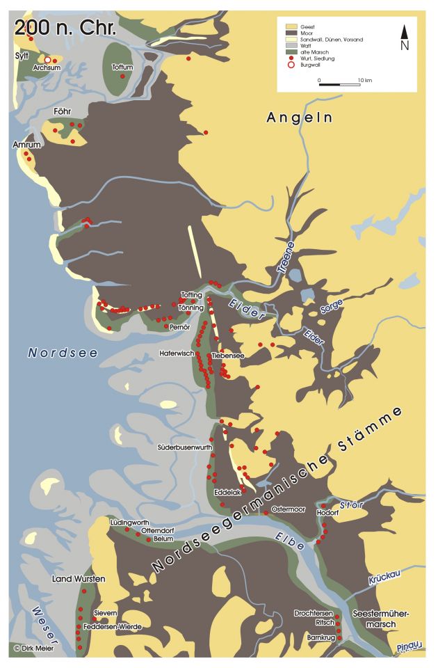
During the Roman period, the coast of Nordfriesland was relatively densely populated. Settlement was concentrated on the so-called geests — sandy and gravelly soils formed as glacial outwash plains (moraines). The word geest derives from the Frisian word güst, meaning infertile land. These geests were formed during the Saale glacial period.
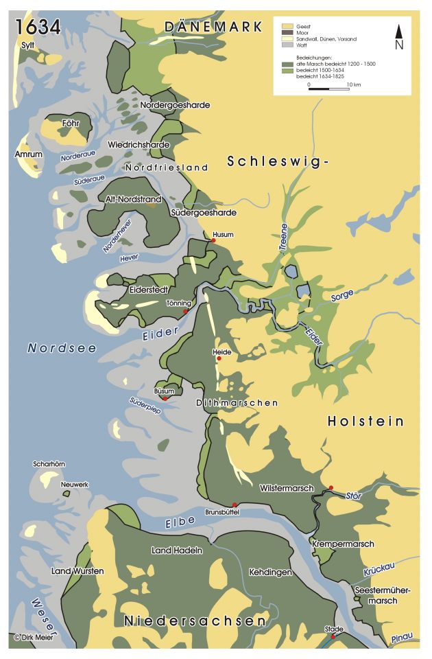
More precisely, settlements were located along the edges of the geests, close to the fertile salt marshes. Habitation existed especially on the islands of Föhr, Sylt (including Archsum), Amrum, and in Wiedingharde, as well as on parts of the peninsula of Eiderstedt. The salt marshes to the south, in what is now the region of Dithmarschen, were also quite densely populated during the Roman period.
INTERMEZZO
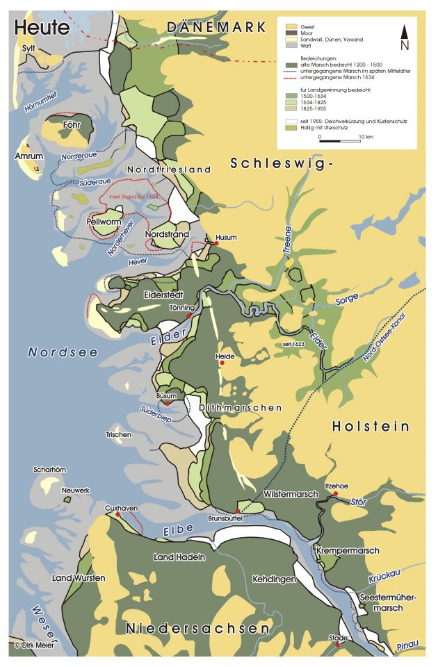
Eiderstedt – The peninsula of Eiderstedt was formed much later, out of the islands of Utholm, Westerhever, Everschop, and Eiderstedt at the end of the Middle Ages and the early modern period. It was the Dutch who were largely responsible for this. Check our blog post A Croaking Ode to the Haubarg by the Eiderstedter Nachtigall for more.
Habitation on the marshes at the mouth of the River Eider began in the first and second centuries AD. These were initially Flachsiedlungen, or surface-level settlements. Settlement became possible due to a period of regression and a less dynamic Wadden Sea. The estuary of the River Eider formed an important corridor for transport and trade, and was therefore significant for the regional economic system. Settlements existed on both the northern bank — including Elisenhof, Tofting, and Welt — and the southern bank, where Hemmerwurth and Flehderwurth were located.
From the second and third centuries onward, however, rising sea levels made it necessary to raise the farmyards. A well-known example is the excavation at Tofting in 1948, which showed that the terp was initially raised to +1.85 metres above ordnance datum (MOD) in the first century, and was gradually elevated to +4.08 MOD by the fifth century. This contrasts with the tidal marshlands of Ostfriesland in Germany and the provinces of Friesland and Groningen in the Netherlands, where a terp culture had already developed centuries before the Roman period. In the region of Nordfriesland, by comparison, terps only emerged during the Late Roman period.
In the fifth century, habitation in the region of Nordfriesland came to an end. As in the terp region of the Netherlands during the fourth century, an inconvenient truth emerged here as well: “you could only hear the seagulls cry.” The population declined dramatically between about 400 and 550, and by the fifth century the land was nearly empty.
From the mid-sixth century onward, the region of Nordfriesland was gradually repopulated. Yet even with these brave new inhabitants, their numbers remained small, and the population during the seventh century was still modest. These immigrants are commonly regarded as Frisian (Majchczack 2022).
2. First colonization wave: the Geestfriesen
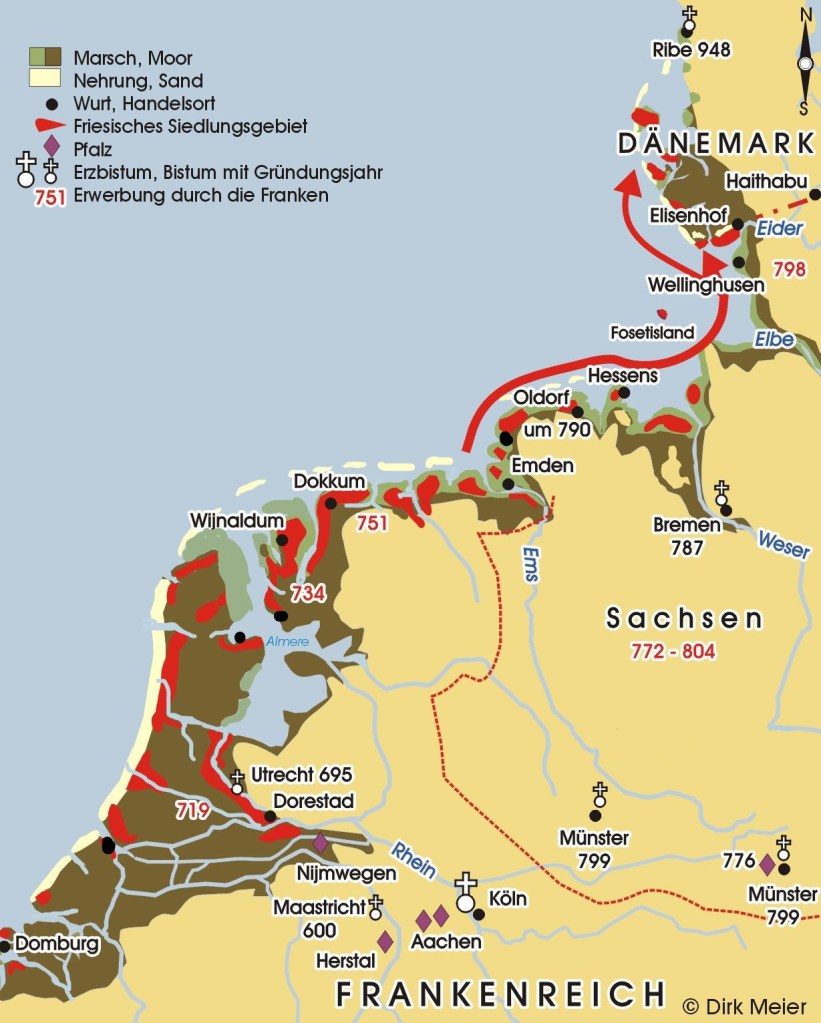
From the eighth century onward, the population in the region of Nordfriesland increased, mainly due to settlers emigrating from southern Frisia. Exactly which part of southern Frisia these colonists came from is difficult to determine, but they most likely originated from the area between the Lower River Weser and the Lower River Ems.
These immigrants settled primarily on the geests of the three Wadden Sea islands of Sylt, Amrum, and Föhr. They also established themselves on parts of the salt marshes of Föhr, the salt marshes of the island of Pellworm, in the Hallig area, and on the Mittelrücken, the central ridge of the peninsula of Eiderstedt. The island of Heligoland in the North Sea was likewise colonised during this first phase of migration. In addition, settlements developed on the higher banks near the mouth of the River Eider. All of these were so-called flat settlements; house podia or proper terps had not yet been constructed.
Looking at the material culture, archaeological research sees parallels with grave goods of southern Frisia. Therefore, the new settlers, or Geestfriesen, were people who were part of Frisian culture. Also, many of the medieval silver coins found are sceattas of the Frisian type. See our blog post Porcupines Bore U.S. Bucks. The Birth of Economic Liberalism about this Frisian money and free trade. Of course, settlers from areas other than southern Frisia must not be ruled out. Together with a probably small original population and the southern Frisians, they admixed into what became the Nordfriesen. From the eighth century onward, Scandinavian influence increased, possibly because of permanent settlers from that region.
A well-known idea is that Scandinavia’s oldest town Ribe, in the southwest of Denmark, was established specifically to attract this rich Frisian trade. Probably Ribe was founded with Frisians involved around the year 700. Of the early-medieval coinage, Frisian sceattas dominate the finds. For more about the history of Ribe and the Frisian connection, see our blog post To the End Where It All Began: The Ribbon-Like Town of Ribe.
An aspect that has received little attention from historians is that this Frisian migration to the north took place during the turbulent Viking Age, and moreover toward, and very close to, the heartland of the Danes. How can this be explained? Were these settlers welcomed, tolerated, or simply ignored? Did they smell too awful, maybe? What reasons might the Danes have had for allowing them to settle there?
3. Second colonization wave: the Marschfriesen
From the eleventh century onward, the peat soils in the region of Nordfriesland have been commercially exploited for the production of salt. This was already the case in the southern and western territories of Frisia, where systematic extraction of salt from peat started a few centuries earlier, around the ninth century. In the process, the Frisians unlocked a huge carbon dioxide bomb into the atmosphere that lay buried for millennia along the north-western coast of Europe: carbon dioxide trapped in the (former) near-endless peatlands.
INTERMEZZO
Global Warming, an old story – In January 2017, the Democratic Republic of Congo hit the news because future palm oil production would mean that big tropical forests with peaty swamps of approximately 150,000 square meters will disappear and shall release 30 billion tons of carbon into the atmosphere. This was calculated by ecologists at Leeds University.
Roughly estimated, the peat areas of Frisia encompassed approximately 25,000 square meters. Thus, 5 billion tons of carbon were unlocked and brought into the atmosphere, if you simply take the same ratio of the Congo basin peatland complex. That is without the cattle and massive dung production, part of Frisian dairy culture for more than 2,000 years. Thank the Frisians for serious global warming! So, building dykes against the rising sea is actually their own problem and own incompetence.
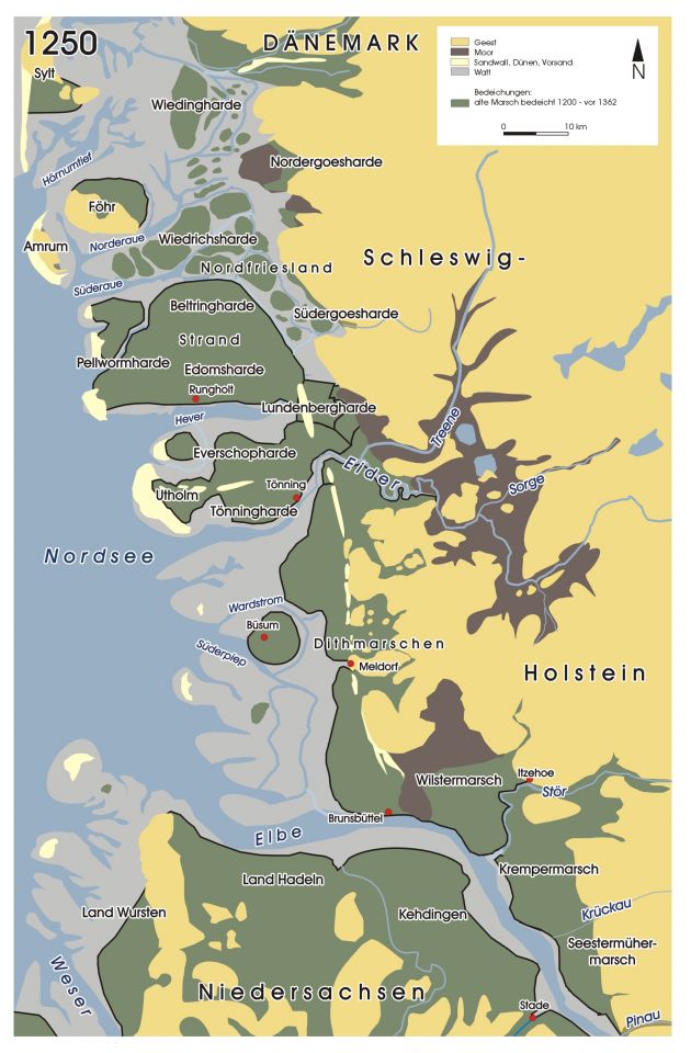
During the High Middle Ages, the population of Nordfriesland increased further, despite the influence of the sea had become stronger from around the year 1000 or so. And, at last, from the eleventh century onward, also terps were being built. In addition, in the twelfth and thirteenth centuries, besides terps being raised, the construction of dykes took a flight, too. Salt marshes, which had grown naturally and silted up over the previous centuries, had become suitable for livestock and for permanent habitation. The so-called Marschfriesen moved in. From then on, these tidal marshlands were protected with dykes from the sea.
It is assumed that the second wave of colonists already possessed the knowledge of how to exploit peatland, how to erect terps, and how to build dykes. Highly skilled migrant workers, one would say in today’s migration policy slang. This second wave of colonists in the eleventh century originated mainly from the mouth of the River Ems.
From the twelfth-century chronicler Saxo Grammaticus, we learn that the new migration wave of mainly Ostfriesen (‘East-Frisians’), led to economic disputes between the so-called Geestfriesen predominantly living on the coastal strip on the mainland, on the one hand, and the so-called Marschfriesen or island-Frisians on the other hand. The Geestfriesen were bound to the leges Danica (‘laws of the Danes’), while the Marschfriesen were bound to the leges Frysonica (‘laws of the Frisians’). Therefore, both had different toll tariffs to pay when passing the narrow Schlei inlet. Furthermore, the Danish king granted the Marschfriesen free use of the tidal marshlands against a yearly payment.
Glück un Nood, de gaht as Ebb’ und Flood!
‘happiness and need, that is like ebb and flood’ (Muuß 1933)
In the year 1362, the Saint Marecellus’ flood, also called the Große Mandränke in the German language, or the Grote Mandrenke in the Low-Saxon language, all meaning ‘great drowning of men’, radically and fundamentally reshaped much of Frisia, particularly the region of Nordfriesland. Regular significant losses of life, land, livestock, and houses were part of Frisian society for centuries, with the region of Nordfriesland not excluded. See our blog post Half a Million Deaths. A Forgotten North Sea Disaster… to give the reader an idea of what living in this dangerous stretch of low-lying land meant.
The Marecellus flood took much land, besides numerous lives. And it was during this great flood that the rich trading town of Rungholt on the island of Strand disappeared overnight into the brown waters of the Wadden Sea forever. See our blog post How Towns Could Drown Overnight. The Case of Rungholt. After the Nordfriesen had recovered from this disaster, the Burchardi flood of 1634, also called the Zweite Große Mandränke (‘second great drowning of men’), put everything to waste once again. An estimated 8,000 to 15,000 people drowned that night. The flood washed away most of the island of Strand, of which only the two islands of Nordstrand and Pellworm, and the two Hallig islands of Südfall and Nordstrandischmoor remain.
4. Celebrating Biikin, its origin
What is there to celebrate with Biikin every 21-22 February after reading the dramatic history of the Nordfriesen above?
The word biik or biikin is related to the English word ‘beacon’, the German word Bake, the Dutch word baken, and, lastly, the Mid Frisian word beaken. So, it is clear what it means: a fire to let ships know where the coast is, and to help navigate through or along it. Beacons are especially vital for navigating the Wadden Sea with all the islands, gullies and the lack of natural landmarks due to the flat landscape. Beacons were placed everywhere at the Wadden Sea and the adjacent shallow inland seas and bays. Maintenance and making sure the beacons were timely replaced when the course of gullies changed, cost money. Therefore, in the early modern period, skippers had to pay a tax called bakengeld ‘beacon money’. Anyway, the reader will understand that beacons, together with such a violent sea history and treacherous coast, belong to the hard-core symbols of this water people.
When the reader thinks back to the two waves of colonization emigrating from southern Frisia in the Early Middle Ages, as described above, combined with the lack of modern means of communication, these fires were perhaps their way to maintain contact with where the Nordfriesen originally came from. Not a beacon for the ships that sailed off, and not to ward off evil spirits. No, it was a beacon to stay in contact with their distant relatives across the sea. The relatives and the motherland these colonists had left behind when they emigrated for better opportunities to an area that would become Nordfriesland.
To follow up on this theme, a more sophisticated explanation is that the practice of the Biikin celebration even dates back to the Great Migration period and testifies to the origin of the Frisian people. The Old Frisian Hunsinger Law Code, written in the early fourteenth century, states the following:
Tha alle Fresa skipad weren, tha leweden hia, hoc hira sae rest thene londgong nome, thet hia ene pictunna bernde end tha otherum thermithe kethe, thet hia londgong nimen hede.
When all Frisians were shipped-in, then they promised, he who went ashore first, that he would light a barrel of pick to indicate to the others, that he had gone ashore (transl. IJssennagger 2017).
So, maybe the Biikin celebration might be part of a social memory of the Nordfriesen and their migration origin (IJssennagger 2017). This theory would imply massive and sudden shifts of peoples in this specific region in order to be traumatic enough to become part of the narration of the Frisians, of which we have not found much concrete information in the books we have read.
Note 1 — Find more about the legends of the North Sea peoples stemming from the Great Migration period in our blog post We’ll Drive Our Ships to New Lands.
Note 2 — Easter bonfires are a similar tradition found across Germanic Europe. These fires take place slightly later in the year, usually on Easter Sunday, at the end of March or in early April. It has been suggested that the flames and smoke symbolise fertility. As with the Petermännchen, effigies are burned during Easter bonfires in parts of Germany and in the region of Twente in the eastern Netherlands. These dolls represent Judas Iscariot. In Low Saxon, the Easter bonfire festival is called Paasbaoke, which translates as ‘Easter beacon’ (Historiek 2026).
Note 3 — Another, cynical, bonfire in the Wadden Sea area is called Holmes’ Bonfire. During the Second Dutch-Anglo War, the English burned down a merchant fleet of 170 vessels in August 1666. This happened in Strait Vlie near the Wadden Sea island of Terschelling. It was Rear-Admiral Holmes who led the attack. Not too bon for the Dutch Republic.
Note 4 — Featured image by Joris Voeten.
Suggested music
- The Pointer Sisters, Fire (1978)
- The Trammps, Disco Inferno (1974)
Further reading
- Balsam, J., Everything you need to know about Burning Man, from someone who’s been three times (2024)
- Bentschneider, A., Biikebrennen in North Frisia (2017)
- Green, D.H. & Sigmund, F. (eds.), The Continental Saxons. From the Migration Period to the Tenth Century. An Ethnographic Perspective (2003)
- Historiek, Paasvuren: eeuwenoude traditie met heidense wortels (2026)
- Holm, S., Sozial- und Wirtschaftsgeschichte des Walfangs der Nordfriesen (2003)
- IJssennagger. N.L., Central because Liminal. Frisia in a Viking Age North Sea World (2017)
- Langhans, V., Über den Ursprung der Nordfriesen (1879)
- Majchczack, B.S., A new light on early medieval North Frisia: Harbours and trading sites on the islands of Föhr and Sylt (2022)
- Meier, D., Küstenarchäologie — Coastal Archaeology (website)
- Meier, D., Kühn, H.J. & Borger, G.J., Der Küstenatlas. Das schleswig-holsteinische Wattenmeer in Vergangenheit und Gegenwart (2013)
- Munske, H.H. (ed.), Handbuch des Friesischen — Handbook of Frisian Studies; Århammer, N., Die herkunft der Nordfriesen und des Nordfriesischen, p. 531-537; Kühn, H.J., Archäologische Zeugnisse der Friesen in Nordfriesland, p. 499-502; Timmermann, U., Nordfriesische Ortsnamen, p. 366-380 (2001)
- Muuß, R., Nordfriesische Sagen (1933)
- Nissen, J., Rummelpott, Biikebrennen, Ringreiten: Über Traditionen und Brüche in Schleswig-Holstein (2019)
- Schuyf, J., Heidense heiligdommen. Zichtbare sporen van een verloren verleden (2019)
- Steensen, T., Die Friesen. Menschen am Meer (2020)
- Tuuk, van der L., De eerste Gouden Eeuw. Handel en scheepvaart in de vroege middeleeuwen (2011)
- Weiler, E., Tanz der Flammen (2011)
