Did you know that between 328,770 and 502,190 people lost their lives around the North Sea? On the flip side: millions of possible casualties have been prevented successfully. For now at least…
Half a million casualties is a lot. How could we forget about such a huge number? Did nobody notice? Did nobody mention? It seems it is not even a public secret. Did we forget about it all together? Are we in denial?
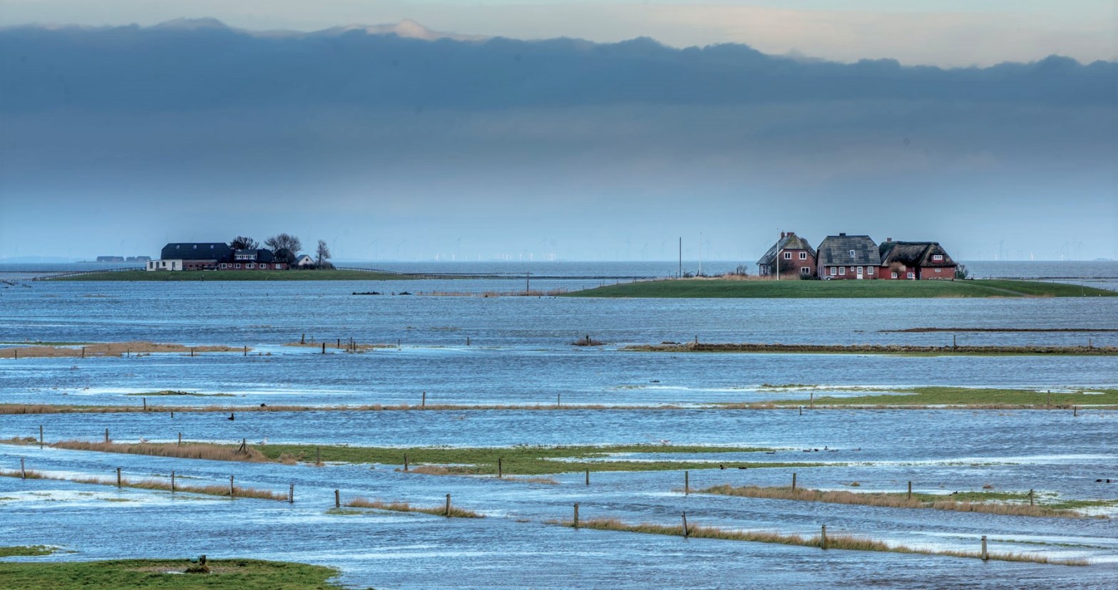
Living along the southern North Sea coast is not easy. It is dangerous. The shoreline is as fertile as it is lethal.
It is like living on a volcano. But this volcano is hard to see. And its lava eruptions are devastating storm floods. Like volcanoes, the sea shapes the land in a drastic manner. You will read in this blog post about the sea creating giant lakes overnight. Some storms take entire islands in one night. Other floods create dozes of islands in just one storm.
For millenniums the coastal people have been living in a deadly embrace with the sea. In the list of deadliest floods ever, the southern North Sea coast, in particular the Netherlands, surfaces three times.
If you talk about climate change, the people of the southern North Sea coast know what you are talking about. And, they developed quite a few successful survival techniques… and stopped having to count dead bodies. Maybe that is why we forgot about this disaster all together.
How did we discover the forgotten North Sea disaster?
So, how did we find out about the great number of deaths? On an old map we accidentally found three islands (right below the island of Rottummeroog) that were washed away overnight and forgotten all together, Heffesant, Bosch and Moenkenlangenoe.
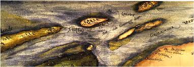
Exploring those islands, revealed that there are many more islands washed away. It inspired us to write a blog post to create an overview of lost islands along the Frisia Coast Trail. It is work in progress. Tips are welcome!
The article is called: Atlantis Found! Wait, There Is Another One, or 7, Wait 12 in Total… No, 19!
So far we discovered 12 islands and 244 villages washed away entirely! That was beyond our imagination. No one ever talked about this disaster, not even our Dutch school teachers. We have one word for that: bizar.
While doing the research we stumbled upon a list of casualties, called Liste der Sturmfluten an der Nordsee. It is a list of storm floods that haunted the southern North Sea coast for centuries.
The list indicates a conservative and realistic number of casualties. So we took the time to calculate the total amount of casualties per century.
We took that as a basis to create a graphic. This is what happened over the last 2,000 years.

47% of the population washed away in four nights is beyond imagination
The floods in the 13th century took 47% of the total amount of inhabitants. Almost half the population! At the time of the flood there were 400,000 people living in the area (see page 9). The floods took 191,000 deaths in total.
Imagine this year only 8.4 million people would die in the Netherlands. That is 47% of the 18 million inhabitants in 2018. Mindboggling.
It is simply unheard of in the history of humankind. Does this huge number of casualties sink in yet? No? Here are some comparisons with some casualties of natural disasters and wars.
- 2.3% of the Dutch population died in the World War II, 210,000 deaths of 9 million inhabitants.
- 0,3% of the Japanese population died due to the Nagasaki and Hiroshima atomic bombing, resulting in 226,000 casualties of 71,000,000 inhabitants.
- 0,8% of the Chinese population died in 1931 in the deadliest flood ever. 4 million people died of a population of 492 million.
Still, not sinking in? Imagine half of your family and neighbours in the street you live in do not make it until the end of the week. That is how many died.
In the 13th and 14th centuries we see a huge peak of casualties. It accounts for 60% of the total deaths. Let’s have a look at the three main murder suspects.
1. First Saint Marcellus’s flood — 16th of January 1219
On the 16th of January 1219, the First Marcellus’s flood took between 36,000 and 100,000 casualties.
The First Saint Marcellus’s flood drowned people along the coasts of the region of Westfriesland (Noord Holland) and the province of Groningen, as well as along the River Elbe and also the Jade Bight.
2. Saint Lucia’s flood — 13th and 14th of December 1287
On the night of the 13th and 14th of December 1287, the Saint Lucia’s flood hit the Dutch and German coasts again. It was a specifically heavy flood taking not only many dykes, but also some 50,000 casualties.
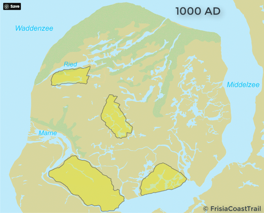
Especially the Dollart Bight area and the Lauwers Sea were hit. The heaviness of this flood created an entire sea: Zuiderzee, the current Lake IJsselmeer, or South Sea as opposed to the North Sea.
3. Second Saint Marcellus’s flood — 15th and 17th of January 1362
This flood was so desastreus that it was given a name of its own, the First Big “Mandränke“. Mandränke translates into English with “Great Drowning of Men”. Indeed, with 100,000 casualties that seems an appropriate name to us.
It swept across the British Isles, the Netherlands, northern Germany, Schleswig, and Denmark, southern Jutland.
The severity of this flood shows in the fact that it created dozens of Halligen, marking the current landscape of the region of Nordfriesland. The storm washed away the North Frisian “Uthlande“, out-lands. All there was left were some islands.
Also the town of Rungholt was washed away in this night. Some 30 to 40 villages were lost.
What would you do after being struck by such bizar disasters? Leave? Not the coastal people. They developed cojones like canon balls. They shook their heads, got their act together and stayed. And more importantly, they brought the number of casualties drastically down. Here is how.
Climate change solution 1.0 — Terps
Storm floods happened throughout all the centuries. What was the answer of the inhabitants?
They were surely not intending to leave this fertile ground. They would stand their ground. They were prepared to move heaven and earth, if they had to. Well, they basically did. Their solution was indeed to ‘move earth’.
The Frisians have been building terps for centuries. A terp is a an artificial mound or platform which protects your farm house from high floods.
Terps are being made for more than 2,600 years. Although most terps have been build over the period 650 BC-AD 1050.
Inspired? Here is a DIY manual — Making a Terp in Only 12 Steps. Have fun!
If you don’t think terps are up to date anymore, think again. Terps are still a useful solution. For example, the Wieringermeerpolder was reclaimed land in the province of Noord Holland somewhere in the early 20th century. In the middle of the reclaimed land (or polder), they built a terp at the village of Wieringerwerf. And, it proofed life saving when the Nazis destroyed the dykes around the polder in the World War II.
Only in the province of Friesland more than a thousand terps have been accounted for. Can you imagine the effort it took?
No? Here is a comparison for you.
It has been calculated that the amount of clay to raise all the terps in the Netherlands is 10x needed for all pyramids combined.
So, you can imagine, the North Sea people are not impressed at all by the pyramids.
They are baffled at most. But for a different reason than you would expect.
Why on earth move earth to commemorate a handful of dead leaders (and kill thousands of people while building it)?
Why not move the earth to save lives of millions of your people?
And, there is more. Here are some statistics. You can do the math.
Some 118 to 138 Egyptian pyramids have been build over a period of 1,000 years. It was calculated that at the times of the construction of the three big pyramids some 1,000,000 people inhabited the land.
We estimate some 1,500 to 2,000 terps have been built in total in 1,700 years. The estimated amount of people living in this region was only around 30,000 to 50,000.
Climate change solution 2.0 — Dykes
After the 14th century the terps were widespread across the coast line. A simple next step was to connect the terps and to create dykes. This helped to reduce the number of casualties drastically.
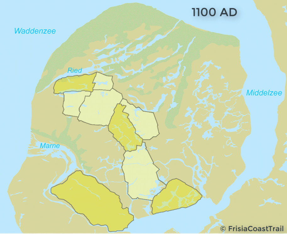
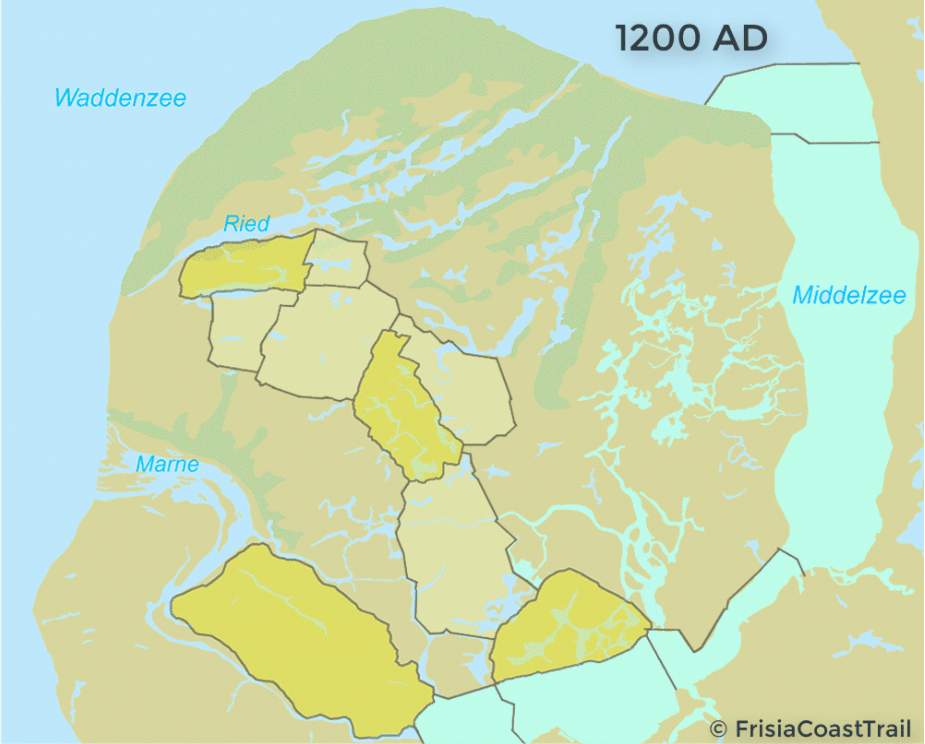
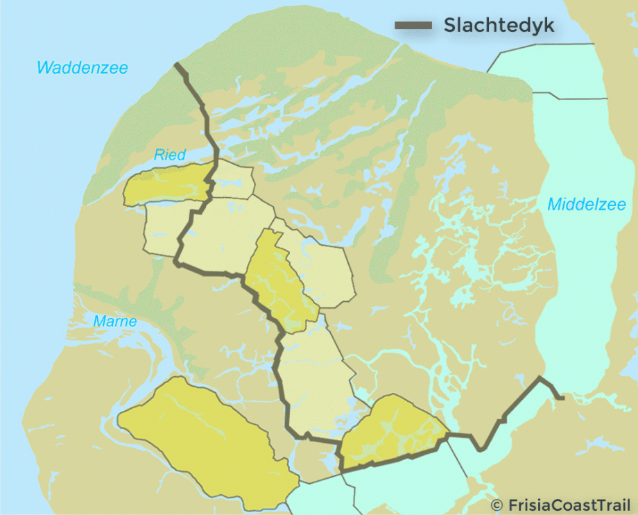
Want to know how the dykes developed over time? This is how is happened in the province of Friesland. The dykes became so important not only for protection but also for transportation that in nowadays Frisian the word for dyke and road is one and the same word namely dyk.
Climate change solution 3.0 — Delta Works
The third solution was implemented in the 20th century. It is called the Zuiderzee and Delta Works. The Works is:
- “A series of construction projects in the southwest of the Netherlands to protect a large area of land around the Rhine-Meuse-Scheldt delta from the sea.
- The works consist of dams, sluices, locks, dykes, levees, and storm surge barriers. The aim of the dams, sluices, and storm surge barriers was to shorten the Dutch coastline, thus reducing the number of dykes that had to be raised.”
The Delta and Zuiderzee Works have been declared, as among the Seven Wonders of the Modern World. So now you know where the claim to fame comes from when they say:
Deus mare, Friso litora fecit
God created the sea, the Frisian the coast
Note 1 — ‘Moving earth’ is also what gave Frisians their name. Check our blog post: A Severe Case of Inattentional Blindness: the Frisian Tribe’s Name.
Note 2 — If interested in the history of terp making as part of the common culture of the southern North Sea coast, read our blog post Between Leffinge and Misthusum — Understanding the Basics of Terps.
Note 3 — Credit featured image by halligbilder.de.
Further reading
- Engelen, van A.F.V. (ed.), Jan Buisman. Duizend jaar weer, wind en water in de Lage Landen. Deel 1. Historisch onderzoek 764-1300 (1995)
- Engelen, van A.F.V. (ed.), Jan Buisman. Duizend jaar weer, wind en water in de Lage Landen. Deel 2. Historisch onderzoek 1300-1450 (1996)
- Engelen, van A.F.V. (ed.), Jan Buisman. Duizend jaar weer, wind en water in de Lage Landen. Deel 3. Historisch onderzoek 1450-1575 (1998)
- Engelen, van A.F.V. (ed.), Jan Buisman. Duizend jaar weer, wind en water in de Lage Landen. Deel 4. Historisch onderzoek 1575-1675 (2000)
- Engelen, van A.F.V. (ed.), Jan Buisman. Duizend jaar weer, wind en water in de Lage Landen. Deel 5. Historisch onderzoek 1675-1750 (2021)

How about the Weihnachtsflut of 1717? It washed away half of the gau Ruestringen and made Buttjadingen for a time an island. The gau disappeared, and the name was resurrected in 1911 as the city of Ruestringen. On the 4th of September 1937 the city was submerged in Wlhelmshaven. Ruestringen was, outisde the Saterland, the only still Frisian speaking area between Ems and Weser. Yep, and I was born a few months before the desolution of that ancient Frisian piece of mud. Being born there, I can read Frisian, Platt, and Dutch, as well as Deutsch. The world is more hillarious than you can imagine.
LikeLiked by 1 person