River Vlie (NL) to River Lauwers (NL)
- Length: 266 km (165 miles) in 13 sections
- Terrain: flat
- Region: Mid Frisia (also Central Frisia)
From the former island of Wieringen to the River Lauwers, marking the border between the Netherlands’ provinces of Friesland and Groningen. Or, a stage also nicknamed the ZZ-Top, since it is from the village of Zurich to the village Zoutkamp, in the northwest of the Netherlands. Now you entered the (former) salt-marsh area. From here until the end of the trail you more or less walk along the Wadden Sea coast, along the UNESCO protected wild life area. And during section 4.6, walk the River Marne and the River Moselle in one day 😉
During this stage you have the possibility to stay in one of the countless medieval churches that have been opened as refugio for hikers and pilgrims. What bothies are for hikers in Scotland, are the churches in the province of Friesland. A concept, actually, that came over from the southeast of England and called champing. Check www.jabikspaad.nl for the terms and conditions to make use of these Romanesque churches.
Trail Sections
- section 4.1: Kop Afsluitdijk — Hindeloopen
- section 4.2: Hindeloopen — Rijs
- section 4.3: Rijs — Balk
- section 4.4: Balk — IJlst
- section 4.5: IJlst — Irnsum
- section 4.6: Irnsum — Wommels
- section 4.7: Wommels — Sexbierum
- section 4.8: Sexbierum — Zwarte Haan
- section 4.9: Zwarte Haan — Het Lage Noorden
- section 4.10: Het Lage Noorden — Great Sminia
- section 4.11: Great Sminia — Holwerd
- section 4.12: Holwerd — Anjum
- section 4.13: Anjum — Zoutkamp
Description
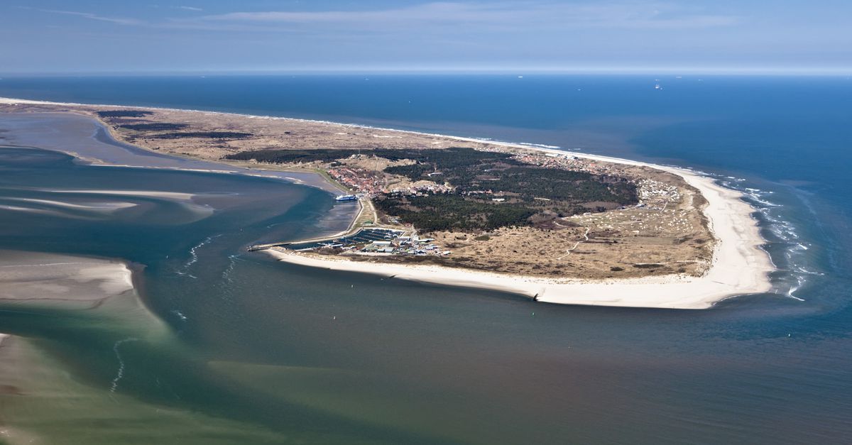
The land is bordered by the UNESCO protected Wadden Sea, together with its many islands stretching all the way into Denmark.
The hinterland consisted mainly of peat areas, which have been mined and excavated through the centuries for the production of salt and fuel. Read our blog post The United Frisian Emirates and Black Peat. How Holland became Dutch about the relatively unknown history of commercial peat exploitation. Dikes were needed to protect the land, resulting in a.o. the Slachtedijk. Read our blog post about this mother of all dikes.
History
According to the early-medieval law code the Lex Frisionum ‘law of the Frisians’ this area belonged to the region of Mid Frisia, also named Central Frisia or Westerlauwers Friesland, the area inter Laubachi et Fli (‘between Lauwers and Vie’). River Vlie, beside its old name Fli, also called Flehi and Flevo, does not exist anymore. But it used to be a river flowing from Lake Flevo, current Lake IJsselmeer, in the Roman Period to the North Sea. Between the present-day islands of Vlieland and Terschelling, the River Vlie flowed into the North Sea.
When we say that the River Vlie does not exist anymore, know that part of it will be restored soon. This is the project Vismigratierivier Afsluitdijk ‘fish-migration river enclosure dam’. It is being constructed 2020-2025.
Early-medieval Mid Frisia consisted of two regions or territories: Austrachia and Uuistrachia, meaning respectively ‘east-island’ and ‘west-island’. Later the names changed into the present names Oostergo and Westergo, meaning ‘east-shire’ and ‘west-shire’, respectively, with the extension –go/-goa/-gouwe/-ga which is, in fact, of Frankish origin.
This is the terp region — terps are artificial dwelling mounds — and it is often regarded as the cultural historic heartland of Frisia. T. But West Frisia, the present-day provinces of Zeeland, Zuid Holland, Noord Holland, and part of Utrecht including pagus ‘territory’ Niftarlake, might very well have a legitimate claim for this title, too. And, of course, do not tell it to the Ostfriesen or East-Frisians in the northwest of Germany. In anyway, the oldest terps are indeed found in Mid Frisia, the region of Westergo, and from there spread to the east along to coast into Germany.
During the Roman Period the tribe living in this area was called the Frisii maiores ‘major Frisians’. The area is part of the 2,600 years old terp region stretching from the River Vlie to River Weser, although terps are also build in Landkreis Nordfriesland in Germany, and in the province of Noord Holland in the Netherlands. Want to build your own terp? read here our DIY manual, the first ever and only on terp-building.
The area is of origin a barren treeless tidal salt-marsh area, and you will encounter salt marshes of the trail during this stage 4.
Photo’s
For a first, visual impression of this stage, click here.
