Altitude
As a rule of thumb: for every 10 kilometres expect to ascend and descend about 7.5 metres, and on to walk on average 3 metres above sea level, dykes included.
High – Besides bridges, highway overpasses, etc., most of the highest spots during the trail can be found in the dunes along the endless North Sea beaches. With 58 metres, the Schoorlse Duinen ‘Schoorl dunes’ in the province of Noord Holland, are real altitude peaks. A close second place is reserved for the dunes on the Wadden Sea island of Sylt in the region of Nordfriesland, with a solid 52.5 metres. The Wadden Sea island of Vlieland has dunes tapping 36 metres, which also happen to be the highest landmark of the province of Friesland. On the Wadden Sea island of Spiekeroog dunes rise to slightly over 24 metres, and are also the highest place of the region of Ostfriesland. The dunes of sea inlet the Zwin in the region of Flanders at the start of the trail, are only about 10 metres high.
But the highest spot of the Frisia Coast area is the rocky island of Heligoland out at the North Sea, namely 61 metres. Still no risks of getting altitude sickness, but the red cliffs impressive all the same. Make the detour with the ferry. A spellbinding place of early-medieval Frisia, known as Fostesland after the goddess Fo(r)seti (see for example our post Liudger, the Frisian Apostle).
And Low – The lowest point of the coastal region, albeit the Frisia Coast Trail does not pass it directly, is 6,76 metres below nieuw Amsterdams peil ‘sea level’ (NAP). It is located near the town of Nieuwerkerk aan den IJssel in the Zuidplas polder in the province of Zuid Holland. It illustrates how extremely low the landscape of the Frisia Coast Trail actually is.
The lowest spot you will be walking during the trail is in the Wieringermeer Polder in the province of Noord Holland, with on average 4 metres below NAP. It is the stretch between the small town of Medemblik and the village of Van Ewijcksluis. The lowest spot in province Friesland is 2.7 metres below NAP at the small town of Workum, also on route of the Frisia Coast Trail. The lowest point of the region of Ostfriesland is near the village of Freepsum at the channel Freepsumer Tief, namely 2,30 metres normal null ‘sea level’ (NN), which again you will pass during the trail.
Equipment
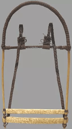
Rucksacks – Your choice of rucksack, a German loanword by the way, or backback, is important. As with all equipment: the lighter the better.
Rucksacks are not a novelty and have been in use since the Stone Age. Also in the North Sea region rucksacks have been used and thanks to archaeological research we also know how the rucksacks of the Middle Ages looked like (see image below). Imagine a Viking leaving his ship with this on his back. So, for the purists this is the type of rucksack you want to use.
Alternatively, stow your belongings in a knapsack or duffel. Again, not invented by the English but this time originating from the Dutch maritime vocabulary of the seventeenth century, namely knapzak and (also) duffel (Chamson 2014).
Footwear – Basically you have two choices: the sturdy rough shoes with support of your ankles or the lightweight running shoes without support of your ankles. Our advice would be to use the latter option. Much of the surface you will be walking on is flat and hard surface. No loose stones or what ever. If possible purchase those that dry quickly too.
Furthermore, when you go hiking the mudflats at the Wadden Sea, these lightweight shoes are the preferred option as well. Heavy shoes will make it a heavy hike. See our blog post Walking on the Sea. Experience It! (With Care) including tips how to hike safely at the mudflats and professional organisations that can guide you on this last dangerous frontier.
See also our blog post Boots Made for Walkin’ on the choices of footwear for the Frisia Coast Trail, including advice on clogs and early-medieval shoes of the region.
Rain gear – Regardless the time of the year, rain can pour from heaven in great quantities. Wearing rain gear to stay dry while hiking in the rain, is always a bit of dilemma. Either you get wet from rain water, or you get wet from your own sweat. At least, protect your backpack with a rain cover, and possibly stow your stuff in waterproof backs inside your backback too.
One tip is to wear a waterproof hat with a wide brim, for example a felt cowboy hat. It is far more comfortable than the hood of your rain jacket, and it gives you the sense of not walking in the rain because the water stays out of your face. A wide-brimmed hat also has as advantage that it gives protection against the sun. Understand that whether it is heavy rain or a bright sun, finding shelter or shade along the route is extremely difficult.
Another option is the typical gear of fishermen of the North Sea, namely a sou’wester or zuidwester in Dutch language. You won’t find them in the hiking store. Go to a maritime shop instead. Zuidwester ‘south-western’, referring to the eternal strong winds and storms from this direction, is of origin a Dutch word (Tempelaars 1991).
Those who really like old-school, try to get your hands on a authentic coroza (cape), carapucho (coat), and polainas (leg coverings) made of reed, the farmer’s coat in the rainy autonomous coastal region of Galicia.
Victuals – There is no need to stuff your rucksack with food. Every day there are possibilities to stock up. Having said that, do take some food and water with you, because the villages on the country side only have very limited stores and eating establishments. Often they only open in the course of the day. Especially off season, local cafés, and pubs can be closed altogether.
